


Pedways: The Dream of a Two-Tier City
Pedways: The Dream of a Two-Tier City
Rise and fall of the skywalker.

Welcome to Londonist: Time Machine. This week, we’re up above the streets of London, exploring the raised walkways of the Square Mile. Had things turned out differently, the City would today be criss-crossed by 30 miles of elevated pathways — a 20th century overtone of the medieval alley network. It never quite happened. But fragments still survive.
Pedways: The Dream of a Two-Tier City
Let me take you by the hand and lead you over the streets of London.
We’re off in search of the City of London’s ‘pedways’, shortcuts through the sky intended to keep pedestrians and road traffic apart.
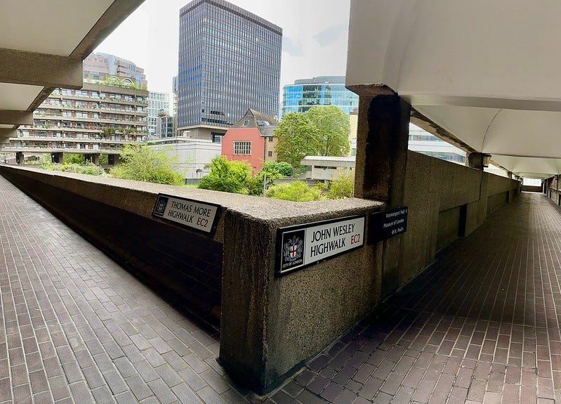
If you’ve walked around the Barbican, then you’ll get the general idea. Here, they are known as Highwalks — spacious, elevated walkways, where you have no chance of being hit by a vehicle (save, perhaps, a rogue scooter).
The Barbican was, and remains, their largest reserve. Here you can roam across 40 acres of city-centre without encountering an internal combustion engine. But smaller pedway fragments can be found elsewhere. They are sorry reminders of an ambitious scheme to criss-cross the City.
Pedways were part of the bold, semi-experimental architecture that shot up after the Second World War. London had long nursed a traffic problem, and the post-war rebuilding seemed like a good opportunity to address some of the issues. Bypasses, motorways, flyovers — the wider city was transformed for the ease of the motorist. We almost lost Camden Town and Covent Garden to road schemes, which thankfully never came to fruition. That’s a story for another day.
Even the Square Mile, despite its tight, ancient street plan and enviable rail connections, found itself bending to the needs of diesel and gasoline. The financial centre had taken a battering in the war. Acres lay berubbled. The opportunity was there to build anew, and build for the motor car.
Space was still at a premium in the crowded City. And so a plan was hatched to shift pedestrians up a level, away from the roaring traffic below. Out of this notion, the pedway network was born.
But what do you mean by a “pedway”?
A pedway is simply a crunch-up of “pedestrian walkway”, a route open only to pedestrians. Not even Deliveroo riders should use them.
The term is not widely used outside of London. It’s not that widely used inside London. But it is the word usually applied to the aerial walkways of the Square Mile. I like it. It’s crisp, descriptive and succinct. The Western Daily Press disagrees with me. They found it a “ghastly word” in 1966. Neologisms always take time to settle.
As far as I can see, the phrase was coined around 1959 by Californian planners. Its first mention in a London context comes in 1965, when the City governance first publicised its planned web of raised walkways across the Square Mile. First to be completed was the reworking of London Wall, which saw a row of slab office blocks connected by a raised pedestrian deck. This would soon join on to the growing Barbican complex, with bridges leading south ready for further extensions. By 1967, all large developments in the City had to build pedway connectors into their architecture. It was a condition of planning approval. This wasn’t so much thinking outside the box, as between them.
The ambition was to build this network out to 30 miles of elevated walkway by 1980. Let’s read that again, and in italics. 30 miles of elevated walkway, and all within the Square Mile. Just imagine. Residents and workers could traverse the whole city without setting foot on the ground. And this wasn’t just about walking. Pedestrians would be able to enter their office blocks and stations at this raised level. All their needs would be catered for. Pubs, shops, laundries — everything that didn’t directly service the motor car would find itself up on deck1.
Had the full scheme gone ahead, then it would surely have spilled out into wider London, with aerial connections through to the West End and Southwark. London would have been a very different city. We would have been very different Londoners. Freed from the fear of traffic movements, and elevated to avian realms, we could appreciate the city with new eyes and new freedom. There is an alternative history novel in this somewhere.
No rational masterplan was ever drawn up, of course. London will forever hiss at such top-down planning. The network was left to develop piecemeal, as additional buildings were added to the scheme. Each had to incorporate apertures and abutments to support future bridges, which in most cases never came. Many of these were still visible in the sides of older office blocks until recently. Now, a spate of new developments mean they’re rarer than a Musk-free news day.
What might the completed scheme have looked like? A map can be found in Pevsner’s guide to the City of London, which every Londonist should have within arm’s reach. My friend Tim Dunn posted a snap on Twitter some time ago. The plan is highly speculative, but based on solid research. It encourages us to imagine walking from Aldgate to Holborn, or the Thames to Farringdon, without ever crossing a road. These pedways are the stuff of dreams.
If you only try one pedway in your life…
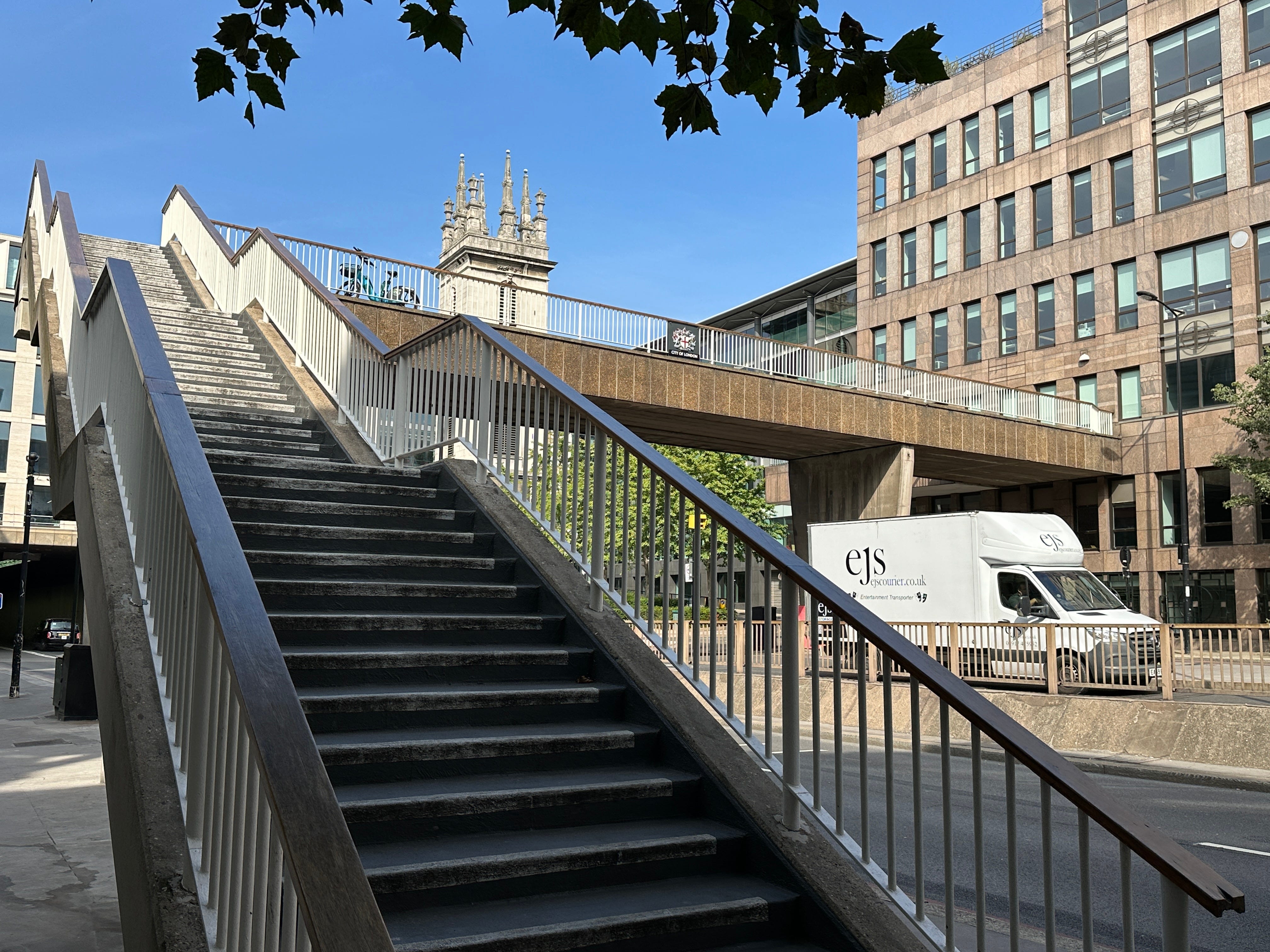
If you really want to see the Power of the Pedway, head to Pudding Lane. Every tourist knows this short street. It’s where the Great Fire started. It’s where they built the Monument. But what few people seem to notice is that the street continues south, in the sky.
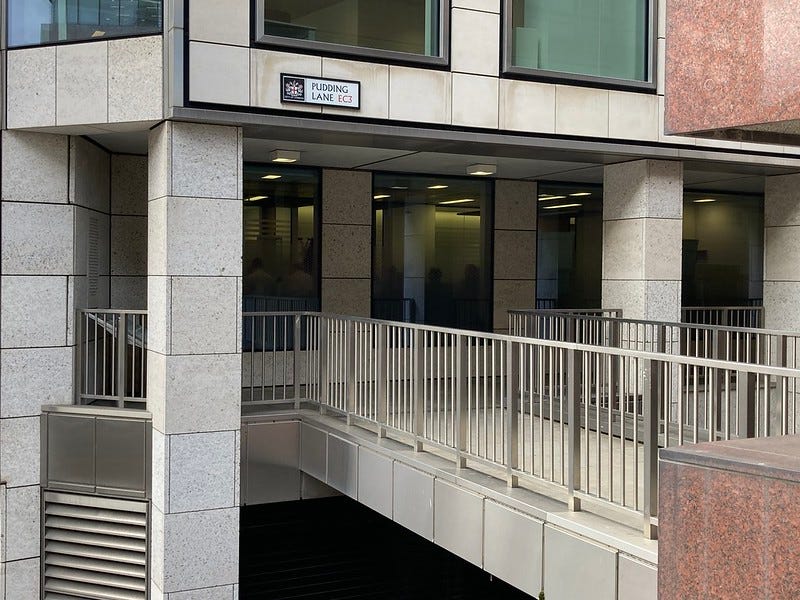
Follow an unpromising set of steps upwards and you’ll find yourself on the most extensive section of pedway outside of the Barbican. A street sign confirms that you are still on Pudding Lane. But this is a magical, alternative reality Pudding Lane that rises like smoke above the traffic and tourists.
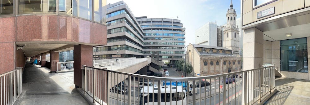
Follow the aerial pavement round a few bends and you’ll skip right over the busy Thames Street, round the side of another building and then, unbelievably, out onto a viewing platform over the Thames. It’s at this point that you start to see how convenient a completed pedway network might have been.
Elevated history
The idea of elevated walkways was not a new one. We could perhaps argue that the walkway over Tower Bridge was London’s earliest pedway, designed for use when the bascules below were open to river traffic. Still earlier, Joseph Paxton’s unrealised plans for a “Crystalline Ouroboros” would have linked all existing rail termini with a circular railway, and what looks like a balconied pedway running throughout. Venice cracked the problem of separating pedestrians and traffic (boats) centuries past. And it will come as no surprise to learn that the over-achieving Leonardo Da Vinci came up with a pedway scheme half a millennium ago. Dozens of other precedents can be found, both here and overseas.
The two biggest names behind London’s post-war pedways were William Holford and Charles Holden, both titans of 20th century architecture. Holden in particular may be familiar for giving us Senate House, 55 Broadway and a couple-dozen tube stations. H&H contributed a report in 1947 that, among other things, advocated the separation of pedestrians from other transport modes. The baton was picked up in 1963 by Colin Buchanan. His highly influential book Traffic in Towns again called for pedestrians to be on a separate level to the traffic. The City of London had already built the idea into its plans for schemes like London Wall, but Buchanan’s book added a further fillip.
The City wasn’t alone in establishing these aerial walkways. One thinks of that wonderful raised passageway along the eastern side of Charing Cross station, which connects to Hungerford Bridge (latterly the Golden Jubilee Bridge). This communicates with the South Bank Centre, which itself supports a network of raised walkways. It was, until a decade ago, possible to follow another footway from the South Bank directly into Waterloo Station. I wish they’d bring it back. Plans were also talked up in the 60s to add pedestrian highwalks through Piccadilly Circus and Regent’s Street, perhaps connecting up to Centre Point, but of course that never happened.
Fall of the skywalker
The pedway network did not fulfil its potential. It settled best in those parts of the City that had been heavily damaged in the war, and were therefore suitable for wholesale redevelopment. The Barbican complex aside, most other pedways stood in isolation, unable to link up to form a network.
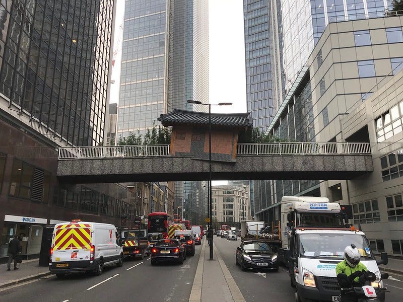
Many have now been demolished. Tower 42 (the former NatWest Tower) once stood at the centre of an extensive sequence. This ranged east, across Bishopsgate into the area where the Gherkin now stands, as well as north across the wall towards Liverpool Street station. Only the Wormwood Street bridge survives, and it is closed off.
Other vanished sections once existed around Paternoster Square and Draper’s Gardens, while the walkways of the Middlesex Street Estate were also publicly accessible (now private). But here and there, fragments still survive. Several bridges still span Upper Thames Street. Fyefoot Lane takes pedestrians over the busy road, round an office block and out onto Queen Victoria Street. Meanwhile, a wooden-slatted bridge links two office blocks just to the west of London Bridge. They get little footfall.
Why did the pedway scheme never really take off? We could put forward any number of reasons — complex to plan; expensive to build and maintain; a growing conservation movement that resisted radical redevelopment; feelings of insecurity on the more isolated sections. But I think the key obstacle was human pragmatism. We just don’t like stairs. A flat but noisy route usually trumps a stepped but quiet route. We could test this at Barbican. I bet more people2 emerge from the tube and walk through the Beech Street tunnel to Moorfields than those who climb up to the Barbican decks and make their way at that level. It’s human nature. Had the pedway network magically sprung complete overnight, it might have been a different story. As it was, its elements were too isolated to tempt people up. You’d no sooner be up there than you’d have to come back down again. The system designed to segregate traffic from people was hopelessly segregated from itself.
Return of the pedways
It’s not all managed decline. A few years ago, a fresh wave of changes came to London Wall. The original roadside pedways were demolished. In their place, a new office complex called London Wall Place was built. It came with a suite of elegant new bridges finished in Corten steel. Pedways: The Next Generation.
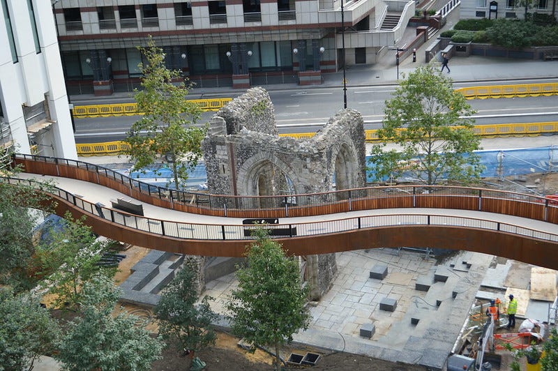
It’s good to see this particular walkway restored, and in such sinusoidal attractiveness. Its presence has an Ackroydian resonance with the past. The pedway you see above tracks closely to the line of the ancient city wall, and at similar height. To walk its deck is to follow the ghosts of Roman sentries and medieval watchmen. This strip of Moorfields has enjoyed an elevated human presence for two millennia.
The pedway 2.0 network recently expanded, adding routes through to the redeveloped Moorgate station, with another bridge awaiting connection to a new development to the south of London Wall. Many are replacements for older pedways, but some are new. The redevelopment of the old Museum of London will add a few more (although it looks like the two old bridges that span the roundabout are for the chop, along with Bastion House, the last of the 1960s office slabs).
I’m not aware of any plans to extend this network further beyond London Wall. But as people turn increasingly away from motoring in favour of more walkable, sustainable streetscapes, especially in the city centre, then perhaps we might see a pedway renaissance. There has long been talk of emulating New York’s successful High Line, with walkways above Camden, and on the redeveloped Bishopsgate Goodsyard viaduct. These would, however, be more like linear parks — destinations in their own right, rather than convenient shortcuts through the sky.
Perhaps the only way the network could ever grow is centrifugally, from a nucleus outwards, rather than hopeful niblets here and there. To that end, the City could promote pedway connections only to new buildings that neighbour an existing access point. It would spread gradually over decades and, perhaps by the end of the century, we might yet see a fully realised network. Of course, by then we’ll all be commuting in hovercars, and the pedways will run below the traffic.
Thanks for reading! As ever, I’d love to hear your thoughts in the comments below. Or feel free to email me (about anything London history) on matt@londonist.com.
A handful of pubs and shops were built along the raised walkways of London Wall, in anticipation of the altitudinal crowds. These were swept away about a decade ago, but not before I arranged a ‘ghost pub crawl’ of their empty shells, to say goodbye.
I know *you* wouldn’t do this. You like exploring. You’d rather enjoy the architecture and fresh air than take the quickest route. But I suspect you’re in the minority.
Interesting, but I would personally prefer these be left to history. There are some raised walkways similar to these in Toronto as well, near the city hall, and they have been out-of-order more often than not in my lifetime.
One of my fears around self-driving cars is that the tech companies and governments involved will eventually give up on having them safely detect and respond to pedestrians and instead decide to "solve" the problem by relegating non-vehicular traffic into narrow bridges and walkways like these.
These walkways were hidden in plain sight. When I started working in London, where the Barbican now is was a bomb site with just the fire station standing amongst the rubble. Over the decades I've seen these Pedways (great word by the way) all over the City, not realising the plan to link them. Great post.