


Unseen Aerial Photos of 1980s Docklands
Canary Wharf... just before it grew skywards.

Welcome to Londonist: Time Machine, the newsletter about London history.
I have an absolute treat this week. A keen reader of the newsletter — who wishes to remain anonymous — has kindly sent me a selection of aerial photographs from 1984. He or she took these rare images at a pivotal moment in the history of London. They show the abandoned quaysides, decaying sheds and moribund power stations of Canary Wharf and the wider Docklands. It is a post-industrial landscape still in quiescence, yet on the cusp of transformation.
That transformation would be so comprehensive that it may be difficult to work out exactly what we’re looking at in each photograph. To help, I’ve recreated the scenes in Google Earth, a technology of science fiction when our anonymous photographer flew over the Docklands just 41 years ago. Comparing the images helps us to better appreciate the enormous changes wrought within the lifetimes of most people reading this.
Looking north to Canary Wharf


We start with the most radical transformation. In 1984, the north of the Isle of Dogs was essentially flat. Few people strayed here, save for the occasional watchman or grit-seeking film crew. Fast-forward 41 years and behold the bulwark of skyscrapers. A quarter of a million people can be imagined within the mid-ground of that second image; in 1984, we’d struggle to reach the hundreds (though note the housing to the far left and right).
We can thank (or curse, should you be a staunch anti-capitalist) the London Docklands Development Corporation for the change. It took control of this abandoned land in 1981 and turned it into a business district to rival the Square Mile. The first tower to go up was, of course, One Canada Square. The pyramid-topped ‘scraper, completed in 1991, remains the tallest structure in Docklands.
I’ve marked its approximate site on the annotated image below, along with a few other ghosts-of-London-yet-to-come.

The historic image captures the area before almost any significant development had begun. The one exception, just visible to the top-right of the docks, is New Billingsgate Market. This wholesale fish market opened in 1982, and is now threatened with closure.
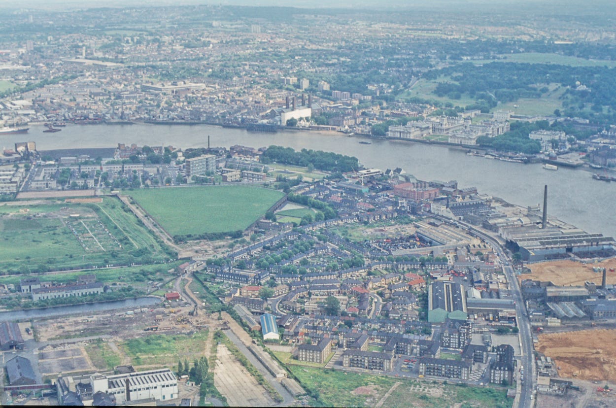
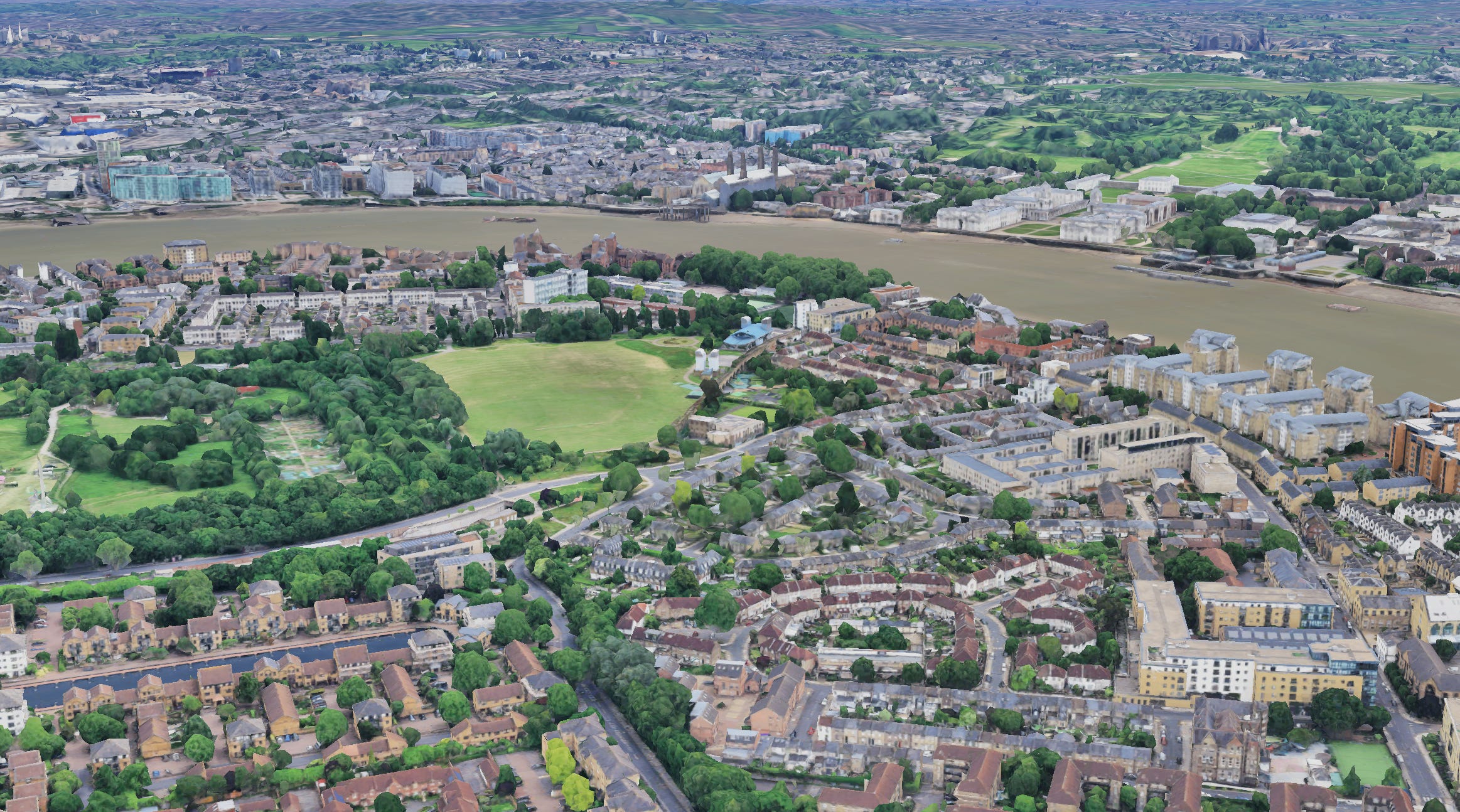
West India Dock and Greenwich Peninsula
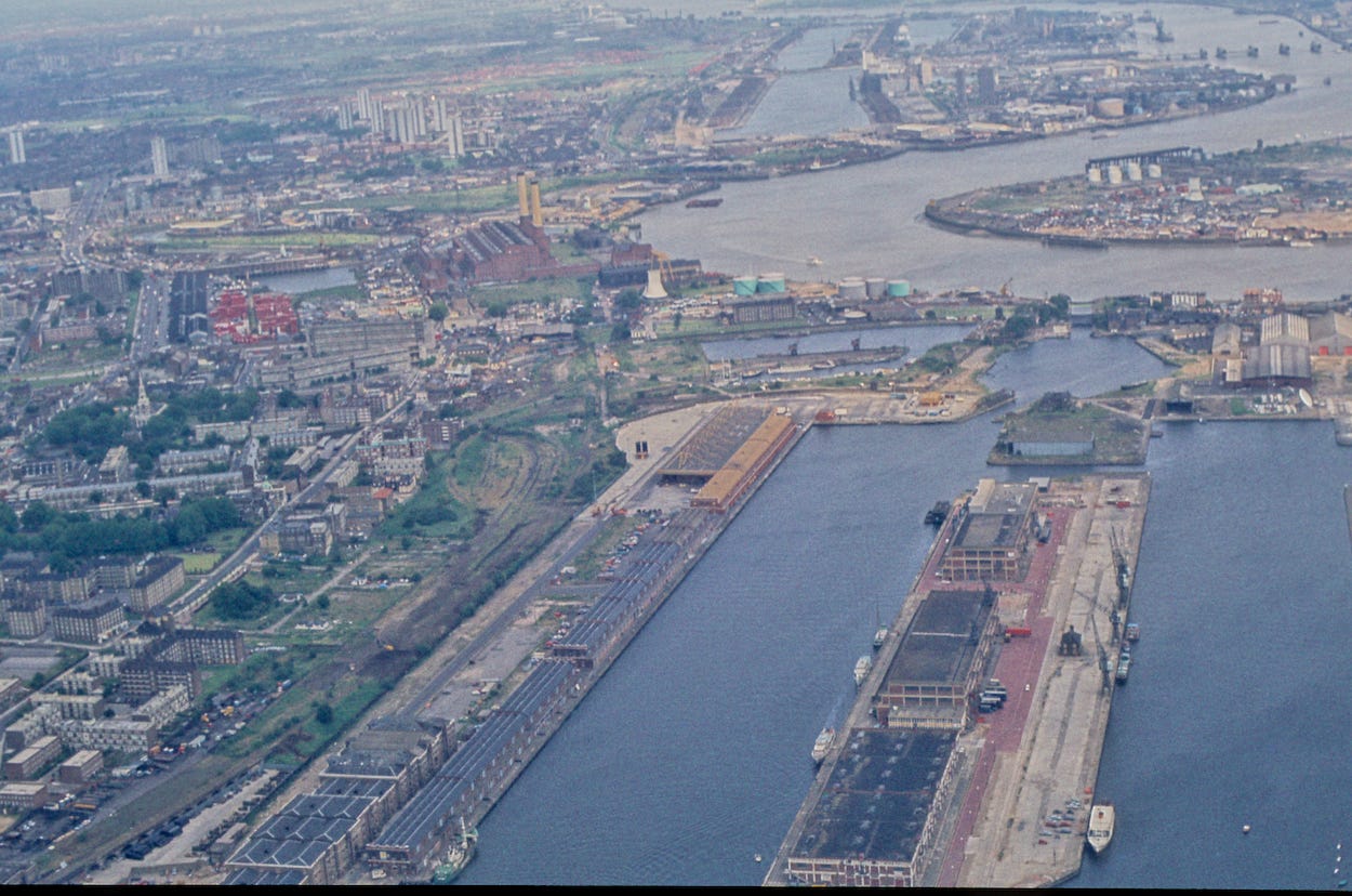

New Billingsgate can be seen more clearly in the centre of this image. We also get a much closer look at the quayside buildings that formed the original Canary Wharf, named because it was the main import dock for products from the Canary Islands.
Greenwich Peninsula peeks into view in the top-right. Today, this land is dominated by the O2 dome and its cultural accoutrements. In 1984, this was an entirely industrial zone, whose main attraction was the Blackwall Tunnel. The other notable feature, towards the top left, is a structure that looks somewhat like Battersea Power Station, only with two chimneys. Happily, we get a closer look in the next photo…
Brunswick Wharf Power Station
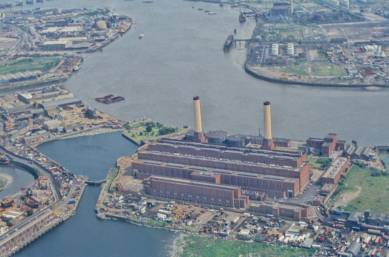

This brickish chunkster is Brunswick Wharf Power Station. If it looks a bit like Battersea Power Station, that’s because it was designed shortly afterwards, though it was not completed until 1956 due to war delays. The architects, Farmer and Dark, were clearly influenced by Giles Gilbert Scott’s better known building.
This coal- and gas-fired power station only lasted about 30 years. It became surplus to requirements and was decommissioned in 1984, the same year as this photograph. It would be demolished four years later. I have to wonder: had the power station survived, might it have found an afterlife like its upstream siblings at Bankside and Battersea? Perhaps this would have become the centrepiece for the Millennium celebrations, rather than the Big Top across the water.
The Google Earth image of the area shows that the power station site is now occupied by apartment blocks, either side of the DLR line. Those white towers are curiously named: Proton Tower, Neutron Tower, Elektron [sic] Tower and Switch Tower — clearly recalling the power station, though perhaps tending more towards nuclear energy for half their inspiration.
The power station’s twin chimneys are today recapitulated by the two pylons holding up the dangleway (cable car) a little downriver. Despite rampant redevelopment in the area, a few sizeable sites of cleared but undeveloped land remain in the modern image.
Poplar
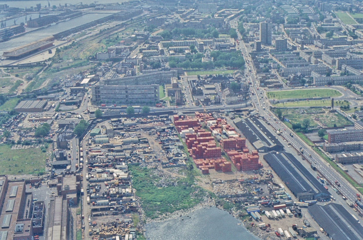

Now let’s flip the view 180 degrees and look westwards towards the Wharf from Poplar. To get your bearings, Norman Foster’s Canary Wharf Elizabeth line station is visible in the top-left corner of the modern image.
We’re mostly looking at Poplar — then, as now, a residential area. We can spot many of the same housing blocks in the two images, and the steeple of All Saints church rises from the top-centre in both pictures. We can also see a very important housing development in the process of redevelopment. Robin Hood Gardens fills the left-centre of the 1984 image, where we see two immense slab-blocks forming an acute angle. This 1970s development was much lauded by the architectural community, though the estate was not without its problems. Its demolition began about a decade ago, amid some controversy.
The Google Earth image shows one of the two large blocks has been completely erased and replaced by modern housing. The second block still remains in this image, though its demolition has since been completed. A section has been preserved for exhibition at the V&A East storehouse, which opens later this year.
The biggest changes, however, have occurred in the foreground. In the modern image, this area is filled with mid-rise office blocks, one of which was Tower Hamlets Town Hall until recently. Back in 1984, the space was given over to light industry, with a sizeable accumulation of shipping containers. Note the water washing into the lower area. This is a remnant of the old East India Dock. There’s still a liquid presence in the more recent image, but it’s tamed into campus water features.
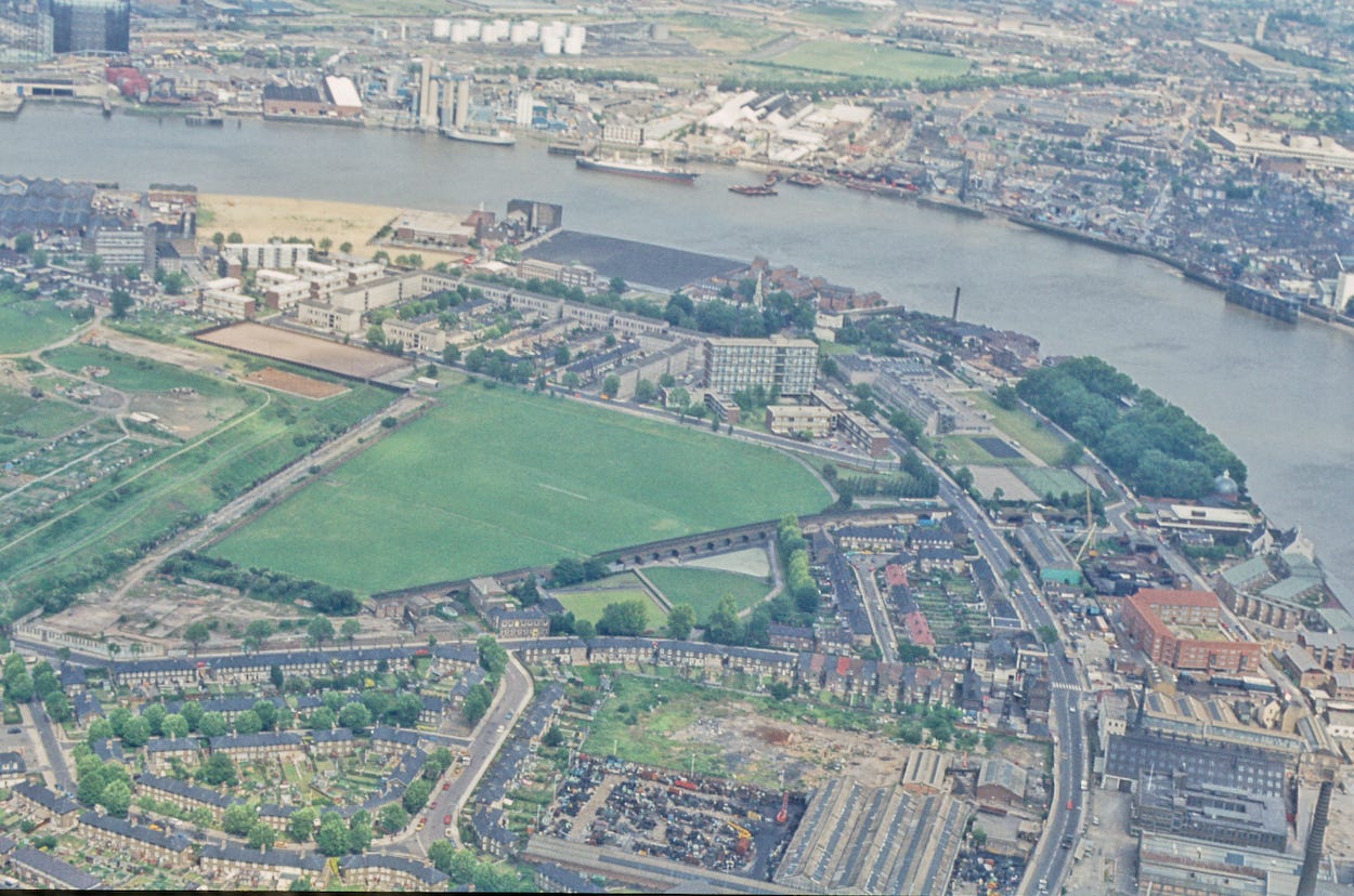
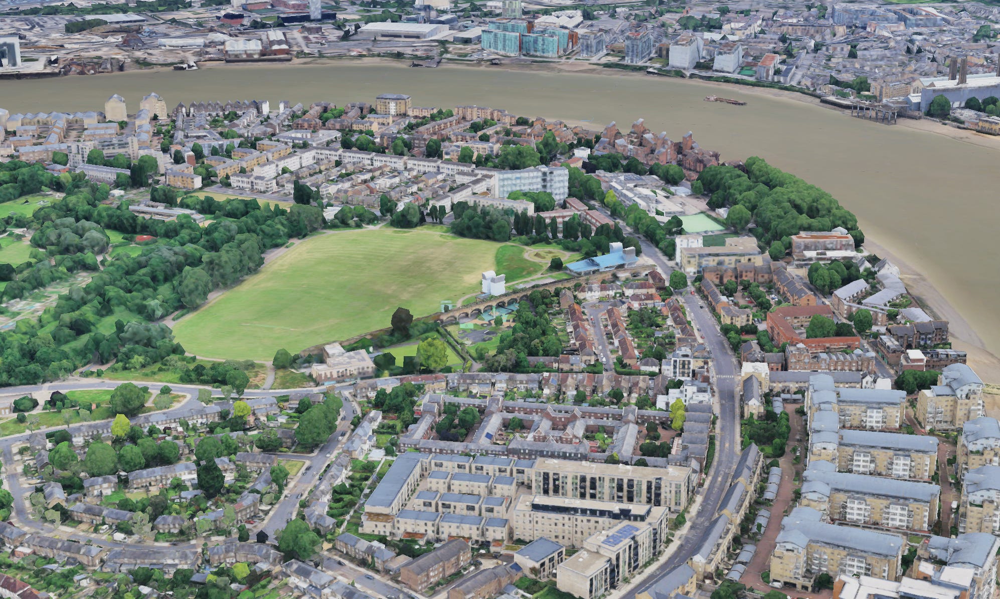
Millwall Dock towards Greenwich
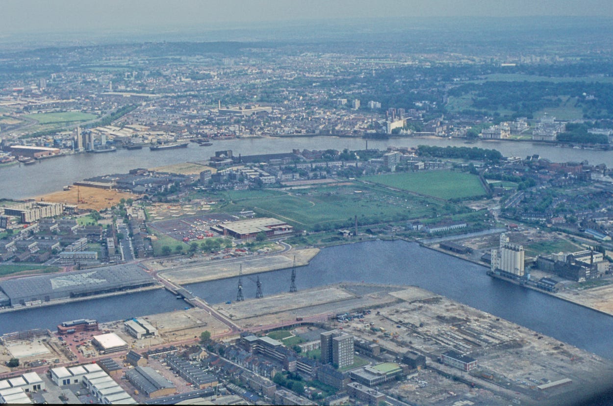

We finish with a series of three views, all of which look to the south-east from the Isle of Dogs. We begin over Millwall Dock, the reverse-L shaped docks south of Canary Wharf.
Looking at the lower-right of the two images, you’d be forgiven for thinking you’d spotted a site that had remained undeveloped through all these decades. Not so. From 1988 until 2017, this patch was home to the West Ferry Printworks — the largest printing facility in Western Europe. The printers played an important role in enabling Rupert Murdoch to shake up the newspaper industry in the 80s, when he moved his titles out of Fleet Street into modern offices at Wapping. The printworks have completely gone now, and a new housing development will soon emerge on the site.
Towards Greenwich
This view leaps over Millwall Dock to give us a closer look at Mudchute Park and farm (mid-left), and across to Greenwich on the far bank. These areas are little changed compared with some of the other views we’ve seen. That said, significant amounts of housing have been added since 1984, especially in the areas closest to us, and along the riverside.
Mudchute Park closeup
Our final view closes in on the tip of the Isle of Dogs. The blue-roofed structure in the modern image is Island Gardens DLR station. It’s the second station of that name, neither of which had been built in the 1984 image. Do you see the viaduct (in both images) heading towards the river? This originally continued almost to the waterside, and it was there that the original DLR station was built. The station hit the headlines in 1987 when a test train over-ran the station and ploughed through the wall. It was left balancing precariously like something from a movie set. Happily, nobody was injured.
The original Island Gardens station closed in January 1999 when the route was extended under the river to Greenwich and on to Lewisham. As a Greenwich resident at the time, I remember this well — though sadly I didn’t have the foresight to take photographs. A new station building (the one with the blue roof) opened just before the Millennium slightly to the north.
One other big change: just look at all those mature trees!
I hope you enjoyed looking through these previously unpublished photographs. Let me know in the comments if you’ve spotted anything interesting that I’ve overlooked. In the next newsletter, I’ll have a second selection of 1980s aerial images, including Stratford, Tower Hill and the Royal Docks.
Thanks for reading! As ever, I’d love to read your comments below. Or email me any time on matt@londonist.com. And a big thank you, once again, to the anonymous reader who sent in the photographs above.
🎞️ Do you have photos of London from the 20th century gathering dust in the attic that you’d like to share with Londonist: Time Machine readers? I’d love to hear from you, especially if they show parts of the capital that have changed radically. Or perhaps you have an old photo of London whose location you can’t identify. Again, I’d love to take a look. (matt@londonist.com)
I grew up in Bexleyheath and used to go skateboarding in Greenwich Park and sailing in Greenland Dock around 1980. I lived in Limehouse from 1990 and saw One Canada Place going up and rode on the DLR into the city on the day it opened.
What memories!
From 1984-89 I lived in Mellish Street (just about visible on the 1st and 2nd photos, a bit to the left of the bridge over the Millwall Dock) so I watched as the area really began to change, and listened to the soothing daily sounds of the numerous piledrivers as the island became a massive building site! I also used to visit the building which had been, I think, a banana warehouse, and before it was finally demolished it was a TV Studio where I saw several episodes of "Who Dares Wins" being recorded, featuring Tony Robinson, Phil Pope, Julia Hills, Rory McGrath and Jimmy Mulville (among others). Mudchute and Island Gardens were visited regularly, as were some of the pubs still open on the island then....