


A New Map Of Medieval London
A New Map Of Medieval London
Deliciously detailed 13th century plan. And a Tudor one, too.

Welcome to your Wednesday instalment of Londonist: Time Machine. We’ve featured quite a few maps in this newsletter over the past year and… well, here we go again. Today, I’d like to share with you a newly created map of medieval London that is, quite frankly, astonishing in its detail. That’s after this quick recap on recent posts.
🧢🧢 RECAP: Last week’s main newsletter featured the surprisingly long history of the airborne police. The Met first took to the air as long ago as 1932 in early autogyros, and were quickly put to the test keeping an eye on Blackshirt rallies. Friday’s subscriber newsletter looked at the dying words (where known) of all the English/British monarchs… and presented them as modernist poetry. Also throwing a curveball, Lydia’s Sunday’s email for paying subscribers looked at Five Moments from London’s Baseball History. We’re nothing if not eclectic! Remember, paying subscribers can also look forward to a visit to the Cinema Museum on 29 June. Drop me a line if you’d like to join us and want more details.
A New Map of Medieval London
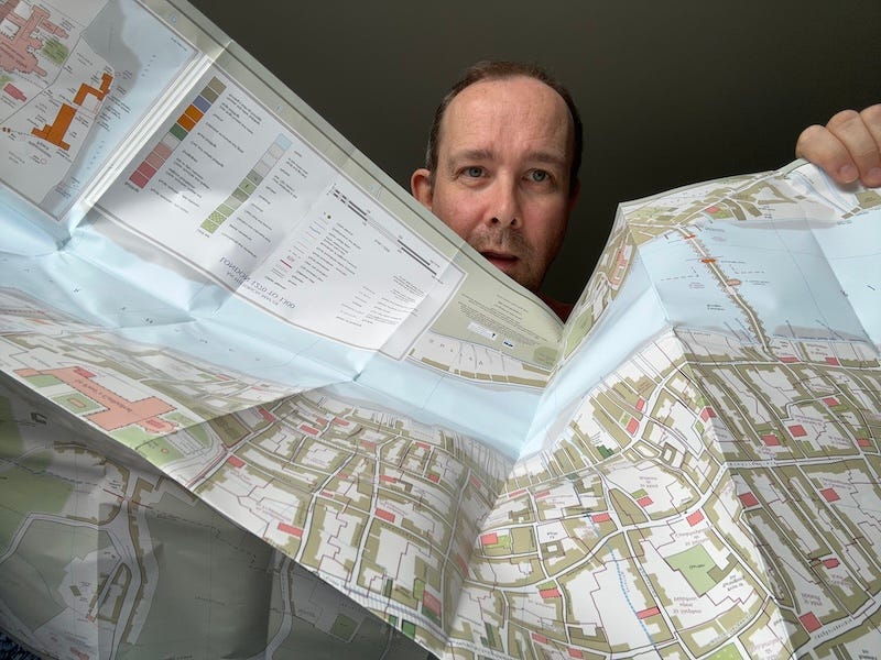
Here’s a slice of 13th century London as you’ve never seen it before:
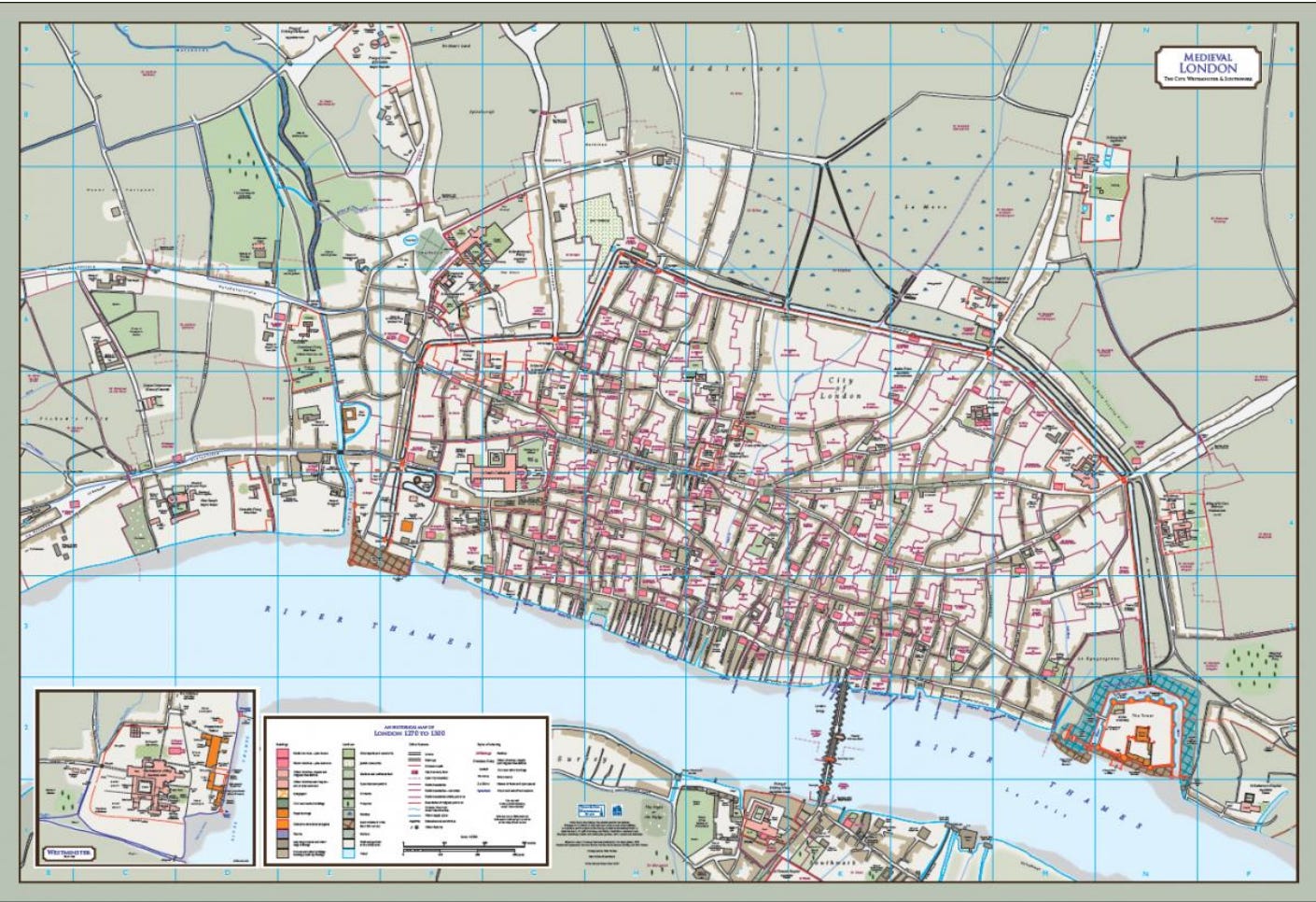
Look at the details. We can see individual parish boundaries, the route of the city wall, long-lost buildings like Baynard’s Castle and Montfichet’s Tower, churchyards, wharfs, moats and channels. This is London in an age before the Black Death and Peasants’ Revolt, when Old St Paul’s was the New St Paul’s (and still under construction). It was, indeed, an age before city maps.
Regular readers will know (because I coloured it in) that the oldest surviving map of London dates to the 1550s. A slightly earlier panorama also exists, but it’s more illustrative and gives little information about the street plan. Before that? No maps. Nothing. The first three-quarters of London’s history, from the Roman foundation to the 1550s, is acartographic.
That doesn’t mean, however, that we can’t map retrospectively. I had a stab, many years ago, at hand-drawing a map of the wider London area in Anglo-Saxon times. That was a fairly low-resolution affair, mapping settlements, rivers and the remnants of Roman roads, all of which are reasonably well attested in historical sources. Anyone with a passion for ‘lost rivers’ and an etymological dictionary of place names could have done it.
But mapping the street plan and property boundaries of the city centre itself is a much more formidable task. That’s where the Historic Towns Trust (HTT) comes in. A registered charity, its mission is to work with local historians, geographers, and archaeologists, to research how and why our settlements developed in the way they did. And, blimey, have they done a good job with London.
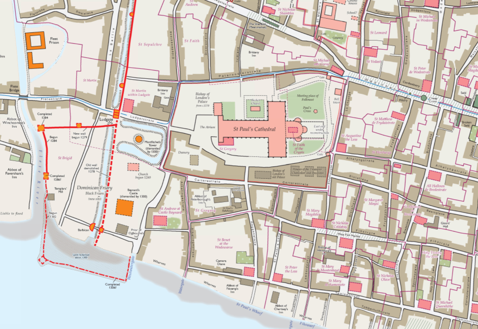
You’re going to want to order these
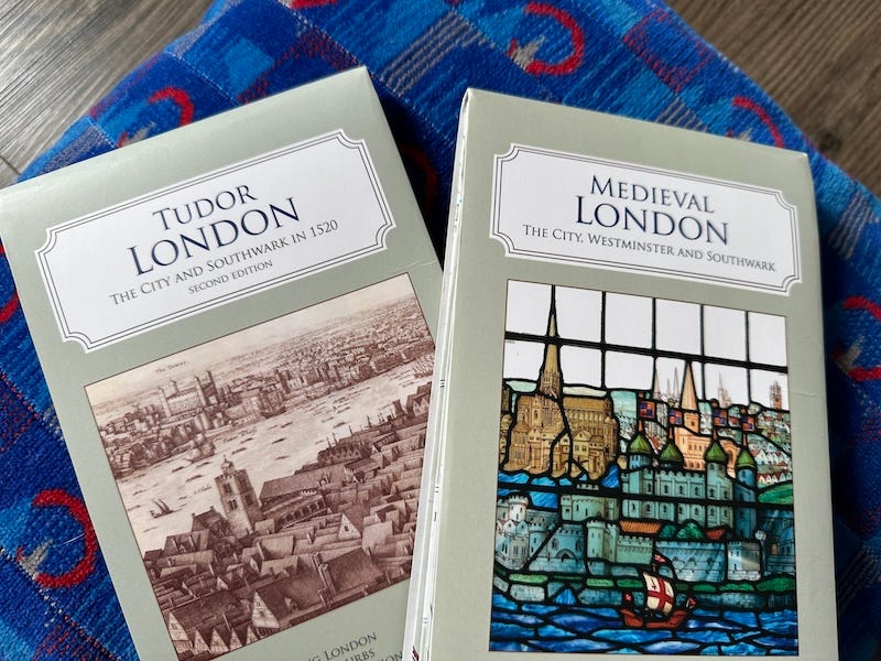
The team have put together two exceptionally detailed maps of the capital. The first, Tudor London, zooms in on the year 1520, showing the city shortly before the Reformation swept away the religious houses. The second map goes back as far as the late 13th century, more than 250 years before the dawn of London cartography.
“It’s about the earliest date we can really map the city in detail,” explains Professor Vanessa Harding, who contributed to the research and is the Chair of HTT. “From the mid-13th century we have a proliferation of written sources for houses, streets and landmarks; all the parish churches were in place, and most of the religious houses, though the guilds had yet to make their mark physically.“
Although no contemporary map of medieval London exists, the team at HTT didn’t have to start from scratch. Their starting point for both the Medieval and Tudor maps was a 1989 volume called The City of London from Prehistoric Times to c.1520, edited by Mary D Lobel. That book was meticulously researched at the time, but is now out of print (though scanned online here) and very out of date. Thanks to archaeologists, we now know so much more about the ancient city than we did in 1989.
The 1989 map was heavily reworked by cartographer Giles Darkes, who wove in all that new archaeological information. He also gave the map a visual overhaul, introducing a much wider range of colours and symbols to bring the street plans to life. The end results are maps of Tudor and medieval London far more detailed than anything seen before.
Both maps are freely available online via the Layers of London website (view medieval here and Tudor here). However, a much better overview can be gained from the fold-out paper copies, which also include introductory essays, and a whole reverse-side of supplementary information. As someone who’s spent more time studying old London maps than is strictly healthy, I can’t recommend them enough.
Gaps in the maps?
“Are there any areas of the medieval map that are educated guesswork”, I asked, “where historical sources and archaeology have little to say?”.
“There are certainly some known unknowns,” says Vanessa, “as well, no doubt, as unknown unknowns!”
As a rule of thumb, the further you get from the city centre, the more the uncertainty. Land use within the walls is well recorded across multiple sources; not so the fields beyond the walls, much of which was marshy. The medieval map includes large fields of blank, named only “La More” (the moor, Moorfields), or “Area of market garden”. What went on in “No Man’s Land”, or the mysterious “The Wyld” of Southwark? We may never fill in the details, other than with the imagination.
It didn’t help that the earliest maps, such as the ‘Copperplate’ and ‘Agas’, give conflicting information about field boundaries. “It was a struggle to reconcile these,” says Vanessa, “as well as the lurking suspicion that the makers of those maps might not have known very clearly themselves!”.

Churches, too, were surprisingly tricky to plot. Their locations are well attested, but their dimensions and footprints are not. Many of the parish boundaries were also uncertain: “We had to triangulate between the 19th Century Ordnance Survey maps, the earliest plan-form map of 1676, and scraps of information from earlier sources about properties being in one parish or another,” says Vanessa. “We feel particularly cautious about suburban parish boundaries c.1300, and would welcome new information on those.”
And there’s more coming soon…
With Tudor and Medieval London under their belts, what other cartographic worlds are left to conquer? “We are planning and fundraising for an atlas of London on the eve of the Great Fire of 1666,” reveals Vanessa, “A massive undertaking.”
Maps after the fire are plentiful and well-surveyed; less so before 1666. “There is no large-scale, accurate map of London before the Fire – until you go back to our map of London c. 1520. In the interim, however, London’s population had increased eightfold, and the new metropolis sprawled widely, joining up with Westminster and merging suburbs into one large conurbation, so the appearance and extent of London were very different.”
This new-found ‘“sprawl” means that the city couldn’t fit onto a fold-out map with sufficiently interesting resolution. Instead, the Historic Towns Trust hope to show their creation as a full atlas. This will also make room for essays, inset maps and a street directory.
Mapping the city in this period will be a challenge, but many primary resources are available. Vanessa points to Leake’s street-outline map from 1666, showing the burnt area of the City, as well as Faithorne and Newcourt’s picture-map of the wider metropolis from the 1650s. (You can have a play with these maps, and other charts of the time, on the Layers of London site, which has them all bundled together and superimposed on the modern street plan.) Countless documents survive from immediately after the fire, including legislation, litigation and even street-by-street taxation returns. All of this will be invaluable in piecing together the map. Even Pepys’s diary might offer up scraps of information that could be woven into the survey.
The project will take many hours of research and mapping, which doesn’t come cheap. Happily, the team have already secured about half the funding, including donations from City livery companies, support from the London Topographical Society, and a grant from the City of London Archaeological Trust. Maybe you could help too? “Support from interested individuals would certainly be welcomed!,” says Vanessa.
That project will take some time to realise. For now, you can get paper copies of both the Medieval and Tudor maps here, as well as HTT’s various other maps and atlases.
My thanks to Professor Vanessa Harding for taking the trouble to explain the background to this wonderful project, and to the wider team for furnishing me with two stupendous new maps to drool over
Thanks for reading! As ever, feel free to leave a comment below, or email me any time on matt@londonist.com with any London historical questions or insights.
I just picked up these maps last month! They're great. Would love to have a Roman London map at the same level of detail.
Thanks for insights into the processes behind these fabulous maps. I Iive in Smithfield, where the Fire stopped, so particularly interested in before and after the fire mapping of that and neighbouring Clerkenwell.