


The 1746 Rocque Map Of London... Now In Colour
The 1746 Rocque Map Of London... Now In Colour
Part 1 of my mission to colour the whole, magnificent map.

It is the first detailed map of London. John Rocque’s 1746 street map picks out individual alleys, courts, ditches and hedgerows. It embodies Georgian London like no other historical resource. And now it’s in colour! Or, at least, one panel of it is in colour, because my latest mapping project is going to take months to complete. That first panel, which contrasts the densely built-up City with the open fields of Southwark and Lambeth, can be found in high-resolution below. First a quick message…
📣📣 Site visits for paying subscribers: I’ve been absolutely blown away by how many people have taken out a paying subscription to Londonist: Time Machine. It really does help to keep the newsletter going and growing. There’s no advertising here, so projects like the full-colour Rocque map would not be possible without the generous support of subscribers. As a thank-you, I’m going to arrange at least three site visits for paying subscribers over the summer months — places of historic interest you can’t normally just walk into. I’d love to hear from you if you have any suggestions (and especially if you have access to somewhere we could take a group). Email me on matt@londonist.com. If you’re interested in becoming a paying subscriber (just £5 a month, or cheaper if you take out the annual subscription), then hit the button below. You’ll also get bonus newsletters and full access to the archive. Oh, and we also do semi-regular drinks nights, where you can meet other London history fans.
The 1746 Rocque Map Of London... Now In Colour (part 1)
Of all the maps of London, the 1746 John Rocque map1 is surely the most beguiling. It is the first map of the capital to go into what we might describe as a geeky level of detail. I mean, just look at this one tiny excerpt around Cornhill:
Every courtyard, alley and church is shown, and we can even see the City’s administrative boundaries snaking across the chart. Fascinating though these street plans are, it’s the outer fringes of the map that have always enchanted me. Here, for example, is the Bankside area:
In this one small section, we see cultivated fields, orchards, tenter grounds, irrigation ditches, ribbon developments of housing, even patches of marshland that have yet to be reclaimed. It’s so rich, so beautiful that it makes me want to weep topographical tears of joy.
Rocque (1704-1762) was diligent in his cartography, using a mix of theodolite-based triangulation from church towers and chain measurements at ground level to produce the most accurate survey then in existence. He also went to great effort to record street names, through personal inspection, consulting earlier maps and with the help of local beadles. The project took him years, and stands as arguably the greatest feat of city cartography of the 18th century.
The one thing the Rocque map lacks is a splash of colour. If you’ve ever seen a black-and-white A-Z map of London from the 1960s or 70s, then you’ll know what I mean. The advent of colour in those maps really helps their legibility. It’s the same with Rocque. All the information is there, but it’s hard to interpret.
Adding colour helps us untangle the complicated patterns of land use, and to visualise which bits of Southwark have, and have not, been developed. When you glanced at the black and white map above, did you notice the 30 or 40 water channels that cut across the map? Probably not. Only with colour does their extent become apparent.
And so I resolved to colour in all 24 panels of the Rocque map. Reader, it took ages, and I’ve only done one so far…
So let’s reveal the full, high-res map…
Here it is. This is the section of the Rocque map covering St Paul’s in the City down to roughly St George’s Circus in Southwark. The colours should be reasonably self-explanatory. Churches are yellow, while all other buildings are red (or left black for named, important buildings). Ward boundaries (north of the river only) are shown as blue dots. Water is in blue, cultivated land is in brown shades, and grass is in green shades.
The first thing we notice is the utter contrast between north and south banks — it’s part of the reason I chose this panel to kick off the project.
Above the river, the Square Mile is almost entirely built up. You’d have to go to St Paul’s or the Temple for a decent kickaround, not that they’d let you. And pity that solitary tree within the cathedral’s grounds.
The land to the south, meanwhile, is a patchwork of fields, with water everywhere, particularly on the western half. Indeed, we can see the word “Marsh” on a street towards the lower-left corner. This is Lambeth Marsh, now Lower Marsh, near Waterloo Station. Part of that primordial bog is still visible on the map, to the north-east of the street.
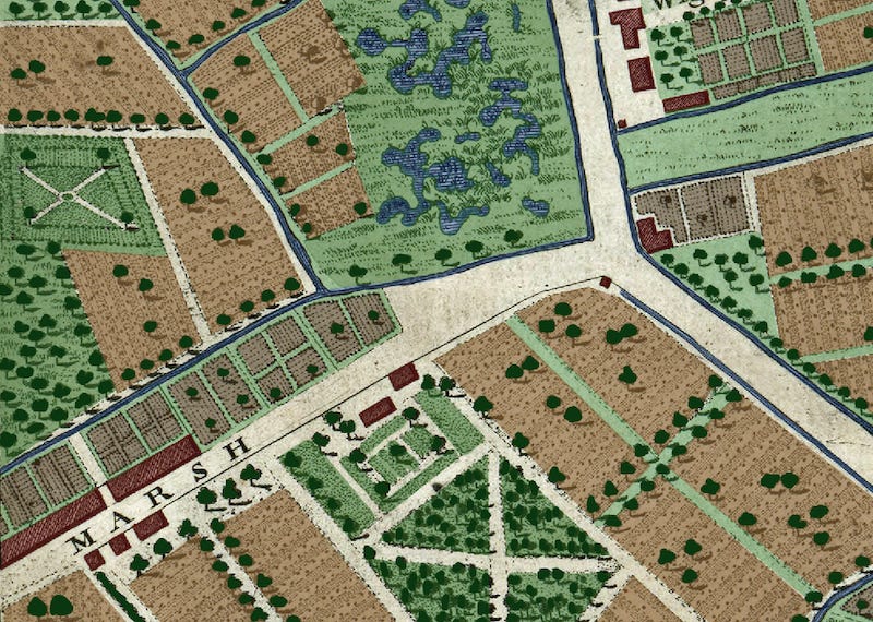
There’s water north of the Thames, too. The River Fleet is still a very obvious feature of the City. It flowed freely from Fleet Bridge (now Ludgate Circus) through a canalised channel down to the Thames. Above Fleet Bridge, its route had been covered over just a decade before the Rocque map. The grey, linear features shown on the map are the two rows of Fleet Market, London’s newest shopping centre at the time of Rocque’s survey.
Running our eyes over the lanes and alleys of the Square Mile, it does not take long to alight on an unusual place name. My favourite junction, north-east of St Paul’s, sees Blowbladder Street join with Jackanapes Row. This is now the busy junction outside St Paul’s tube station but, alas, it has lost its enigmatic names.
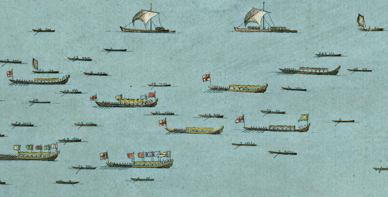
The Thames itself is of interest. No bridges are present on this panel. Blackfriars Bridge, which would follow the alignment of the Fleet across the Thames, was still 20 years away. Southwark Bridge would be built just off the eastern extreme of this panel in 70 years’ time. Millennium Bridge, which now runs due south of St Paul’s, wasn’t even close to a twinkling in a gamete’s eye.
What we do see is dozens of vessels sailing and rowing along the river. Clearly, we’re looking at some kind of flotilla. The larger boats fly sizeable flags, some of which are recognisable as the City of London’s St George-with-sword. We’re almost certainly looking at the Lord Mayor off on a procession to Westminster, as painted by Canaletto a year after Rocque’s map. Many of the ceremonial boats were painted in gold leaf, as shown on my colourised map.
I could wax lyrical about any given corner of this map. There is so much to absorb. What I think I’ll do is leave you to explore it at your leisure. I’ll then be back in Friday’s email to take a closer look at the southern portion of the map, which I find most fascinating.
Where can I explore the original map?
I’ve only coloured one-twentieth of the John Rocque map with this first instalment. If you’d like to jump ahead and look at the wider black-and-white version, then several websites have copies at reasonable resolution. Perhaps the best place to explore it is over on the Layers of London website, which lets you fade the map in and out, so as to better compare it with a modern-day street map. The site can be a little cumbersome to use, so you might alternatively like to download high-resolution panels from the Library of Congress resource.
Like this? Then check out my colourised versions of London’s oldest map, from Tudor times. Available to paying subscribers.
Copperplate map 1
Copperplate map 2
Copperplate map 3
Thanks for reading! And more on this topic in Friday’s newsletter (free to paying subscribers, and a generous teaser for everyone else). I’ll publish a second panel of the coloured Rocque map in a few weeks… they take many hours to do.
Feel free to email me anytime on matt@londonist.com about this map or any other aspect of London’s history.
He actually published two maps of London that year. The second, which I might eventually get to after working my way through the street map, zooms out to show us the surrounding fields “near 10 miles around”. John Rocque was the one-man-Google-Earth of his day.
You can really see the gentility fading away as you head south - you start on Paris Garden Lane, then it's Green Walk, then Bare Lane, then Gravel Lane, then Dirty Lane. Travellers should stop before they hit Grimpen Mire.
Ah... Melancholy Walk. Many a time have I taken a stroll down there after a night at the Ministry of Sound.