Welcome to Londonist: Time Machine, the newsletter of London history.
And welcome to the latest instalment of my multi-year mission, to colour in the John Rocque map of London from 1746; every building, field, church, orchard, river, hill and tree. The map below has been around for more than a quarter of a millennium, but has always been black and white. You’re among the first to see it in full colour, and I hope you enjoy exploring it.

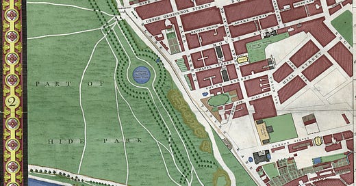
Today’s map takes us to the occidental limits of the chart; where the city peters out to become a royal park. It’s a map of two halves. On the upper-right we have the emergent sprawl of Mayfair. Many of its key streets and squares are already in place in 1746 but we also find large plots of empty land. Look just above Curzon Street, for example, and we can see rectangular and triangular plots, seemingly marked out for imminent development. These are the frontiers of the West End, captured in semi-fledged form.
In stark contrast, much of the western half of the map is undeveloped. These are the fields of Hyde Park, recorded here as Hide Park. The former royal hunting grounds had been a public space for about a century at the time of the map. They contain various features, some familiar others not, which I’ll briefly describe below.
Further fields lie below the ribbon development of Knight’s Bridge. This is the future Belgravia. It would have to wait the best part of a century before the arrival of bricks, mortar and stucco.
This map contains numerous intriguing details, some of which I’ll explore below. Before we dig into the detail, though, here’s a bit more background for those who are new to the project (skip the next section if you’ve read this before):
What this is, and why I’m doing it
John Rocque’s 1746 map was by far the most detailed survey of London up to that point. Across its 24 sheets, you will find the names of thousands of alleys, wharves, lanes and landmarks, mapped in a clear, consistent style. And all of it was done for the first time with (reasonably) accurate surveying methods. It is, quite simply, one of the great treasures of London.
I’m adding colour to this previously black-and-white map for several reasons:
(1) It helps us to see the patterns of land use (urban versus agricultural versus marsh and moor and meadow). It also reveals the hidden watercourses, City ward boundaries, churchyards, parterres, partitions and plantations that made up the 18th century city. All this information is on the black and white original, but it’s much easier to distinguish with a bit of colour.
(2) It’s a lot of fun to spend many hours poring over my favourite map and, I suspect, I’m getting to know it better than anyone alive. That means I might spot a few details that have been missed before.
(3) It amuses my kids to know that daddy likes colouring things in as much as they do.
I’m going to let the map do most of the talking in today’s newsletter. Explore it at your leisure and see what you can discover. But I would like to pick up on a few highlights below. I suggest you have a copy of the map open in a separate tab or on another device, so you can alternate between the map and the commentary.
From Tyburn Tree to Hide Park Corner
I really enjoyed colouring this map in. It’s not just the contrast of rus beside urbe, but also the details. This section is generously scattered with illustrated milestones, a gallows, turnpikes, brickfields and a reference to military slaughter. Let’s explore a few features (in alphabetical order).
King’s Old Road to Kensington: Anyone wishing to head west from ‘Hide Park’ Corner is spoiled for choice in 1746. You might stick on the main road through ‘Knight’s Bridge’, though you would have to pay a toll at the point where it says ‘Turnpike’ on the map. We then see three lesser tracks leading off west, one unlabelled, above the Serpentine, and two below. These are the King’s Old Road to Kensington and the King’s New Road to Kensington. The old route was laid on the orders of William III towards the end of the 17th century. He wanted a private road to reach his main palace at Kensington. The ‘new’ road was built not long before the map, as a secondary route, used by fashionable people to promenade up and down. Both routes survive today as Rotten Row (thought to come from Route du Roi), and South Carriage Drive. The track north of the lake is also still there, as Serpentine Road.
Mile stone at Hide Park Corner: The busy mega-roundabout of Hyde Park Corner is today noted for its collection of monuments. It had one back in 1746, too. Look to the top-centre of the excerpt above and you’ll see the pointy form of a Mile Stone, right next to Hide Park Gate. This obelisk was used as a standard for measuring distance from London, particularly to the west. To this day, it’s possible to find surviving milestones that still record the mileage to Hyde Park Corner. I photographed this one in Bedfont near Feltham:
Milestones such as this were once much more common, placed every mile along prominent roads, especially turnpikes. They were used not only to give a general sense of distance, but also to calculate fares and haulage fees. It’s not clear when the mile stone at Hyde Park Corner was removed.
Part of the Serpentine River: The Serpentine lake was only about a decade old when John Rocque surveyed his masterpiece. The lake had been created on the orders of Queen Caroline, wife of George II, as a means to beautify the park. The artificial lake was formed by damming the River Westbourne, which flows from Hampstead Heath down to Chelsea. Today, the river is entirely underground (well, apart from when it runs in a pipe over the platforms at Sloane Square station). In our map, however, we can still see its continuation to the south of the Serpentine. The second part of the name ‘Knightsbridge’ comes from a literal bridge over the River Westbourne. (The ‘knight’, since you’re now wondering, is thought to come from the Old English word cniht, meaning ‘young men’.)
River Tyburn: The Westbourne isn’t the only ‘lost river’ on this map. We can also see parts of the Tyburn, whose ancient route through Marylebone and Mayfair is still evident in the street pattern. It only makes an unlabelled cameo on the present map. There it is, poking in at the top-right, above the ‘O’ of Tiburn Road (Oxford Street). It’s then hidden under the diagonal of South Moulton Row. However, it re-emerges for a cheeky dog-leg to the south-east of Curzon Street before disappearing once more.
Reservoir of the Chelsea Water Works: Here’s an oddity for you. That circular pool of blue to the left of centre is actually an exclave of the River Thames. Two Newcomen engines at Chelsea would pump Thames water through pipes up to this reservoir, and two others in Green Park. From here, it was readily distributed to the streets of Mayfair and beyond. The pool was long ago filled in when London got a proper mains water supply. But the location is still hydrous today...
The softly pornographic Joy of Life Fountain, designed by T. B. Huxley-Jones, stands on precisely the same spot as the old reservoir. Sadly, it wasn’t flowing when my photograph was taken.
Tiburn: The John Rocque map is studiously consistent in its symbols. Trees always conform to the same basic shapes; buildings are forever hatched in the same brickish style; agricultural land is homogeneously furrowed, whether in Stepney or Southwark. Only very occasionally do we find an individual flourish of the pen. You can see one such mark below:
As most readers will know. Tiburn (usually written Tyburn) was the main public execution site from medieval times until 1783 — 40 years after this map. This ancient junction, first laid down in Roman times, is today’s Marble Arch, where Oxford Street meets Bayswater Road and Edgware Road. It was here that thousands of Londoners breathed, sobbed, sighed and gulped for the last time. That triangular-shaped frame was the gallows, known as the Tyburn-tree. It is accurately depicted, as shown in this recent mock-up at London Museum Docklands:
Other morbid weights burden this junction. Just south of the main gallows is what appears to be a stone marker. Its label: “Where Soldiers are Shot”.
This is the 11th panel of the Rocque map that I’ve examined, and it’s the first time I’ve seen a label that is descriptive rather than nominative. “Where Soldiers are Shot”. It’s so matter-of-fact. Like “Where milk is sold,” or “Where horses are stabled”. Who were these men, and why did they meet the firing squad? Did it happen often? Why can’t I find any accounts in the newspaper archive, or other obvious sources? There’s nothing else like this label on the map. Rocque must have had a reason for adding it. Perhaps one of his wealthy sponsors came from a martial background and wanted to make a point of it. I’ve no idea, though I’d love to hear from anyone who’s researched this further.
I also wonder if the stone, clearly marked above the soldiers label, is the mysterious Ossulstone I’ve written about previously. This tragically loaded corner of London has many secrets still to unpick.
I’ll leave it there. This panel features many other curiosities and talking points, but now it’s your turn to have a look around. Feel free to point things out in the comments section.
The wider map
Before I leave you, here’s a low-res compilation showing all 11 of the 24 panels I’ve coloured in so far. 11 down, 13 to go… although many of the remaining panels are less urban, and thereby more swiftly behued.
The files I’m working with are about 50 cm by 70 cm. That means the entire map, if printed out, would be four metres wide and over two metres tall. You can see why it’s taking many months to colour in! Any galleries or museums reading this, with a suitably sized wall… I’d love to hear from you. It’s my ambition to get the complete map printed out and displayed somewhere, once complete.
Previous sections (available to paid subscribers):
Southwark and the western City (plus the 50 lost waterways of Southwark)
London Bridge, Borough and the eastern City (plus the lost waterways of Borough)
Wapping and part of Bermondsey (plus lost roads of the East End)
Bloomsbury (plus its dehydration)
Clerkenwell and Smithfield (plus the lost places of Clerkenwell)
Barbican, Moorfields and Bishopsgate (plus Who was this John Rocque fellow anyway?)
The East End (Spitalfields and Whitechapel)
Thanks for reading! As ever, please do leave a comment below if you’ve spotted something curious in the map, or even if you have fond memories of this part of town. Or email me any time on matt@londonist.com
Another feat of wowsomeness from M@, nipping out of the Tardis in his tricorn hat!
In regard ‘where they shoot soldiers’. My take on the matter-of-factness is, ‘everyone knows this is the execution place- but condemned red coats are shot according to army rules and regs, not hanged, and that happens here.’👉🏼
Hi,
Did you know that Chawton House in Hampshire (Jane Austens brothers house) has a John ROcque map displayed across several room divider styly screens? I saw it a couple of weeks ago and thought of your. More details here chrome-extension://efaidnbmnnnibpcajpcglclefindmkaj/https://chawtonhouse.org/wp-content/uploads/2018/12/TFSWINTER2011.pdf
I wonder if they would be a good place to display your coloured in map next to it?
Mary