Welcome to the Friday edition of Londonist: Time Machine for paying subscribers, with a pint-sized teaser for everyone else.
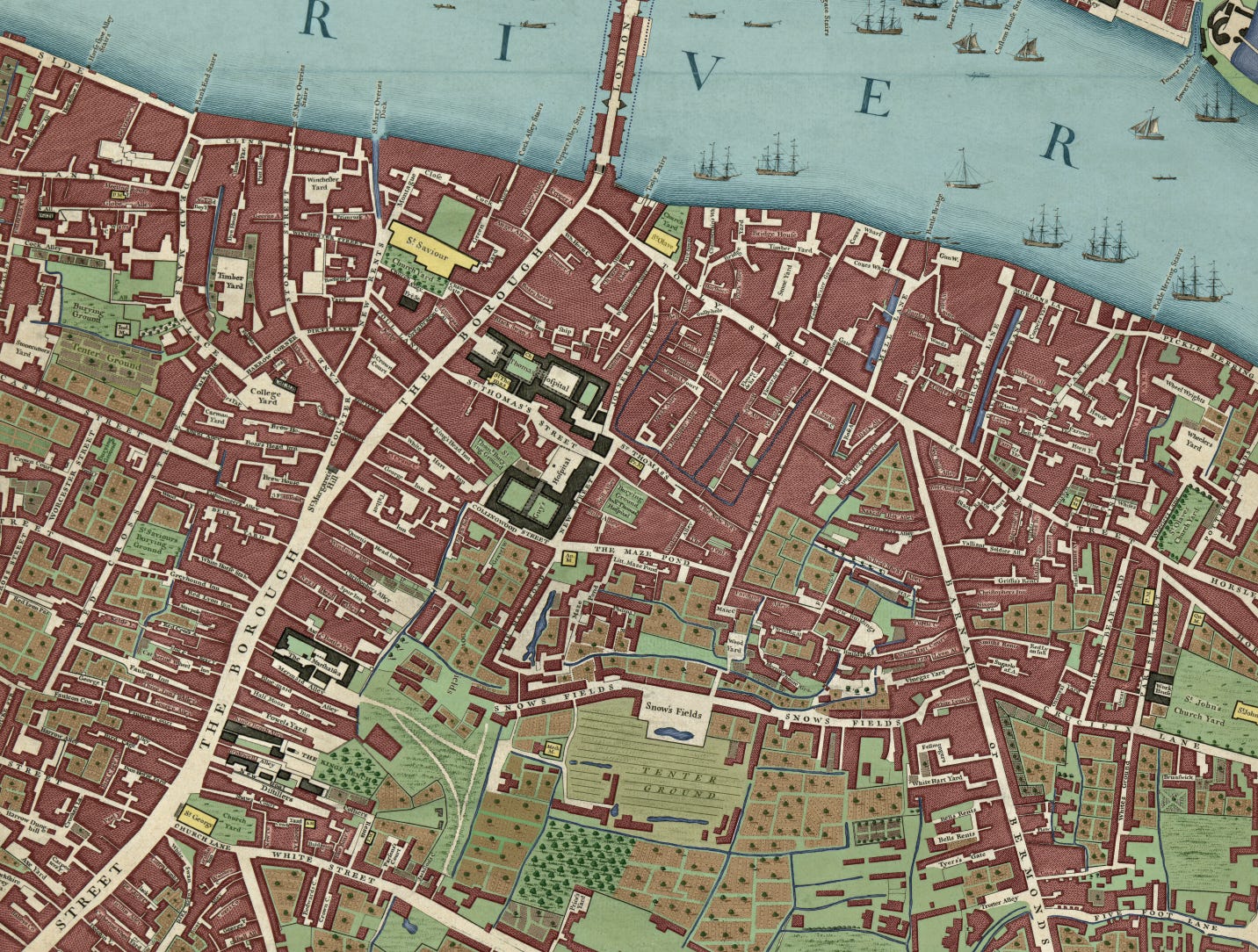
Earlier this week, I published another colourised panel from the 1746 John Rocque map. Today, I’m following up with a short addendum. As I started colouring, it soon became clear that Southwark in 1746 was criss-crossed by many brooks and drainage ditches, which have now entirely disappeared from the streetscape. Today’s newsletter takes a brief look at their locations, much as we did for the Lambeth map a few months ago.
That’s for the main section. First, the History Radar.
History Radar
Upcoming events of interest to London history fans.
🏠 OPEN HOUSE LONDON: It's the most wonderful time of year! All manner of London historic buildings and structures, which are usually off-limits to the public, fling their doors open and welcome us in for Open House London. Lots of pre-booked events are going fast, but there's plenty of stuff you can walk up and do on the day. Begins on 14 September and runs through to next weekend.
🛫 DAM BUSTERS: Historian Richard Morris gives a virtual lecture about the life and legacy of Barnes Wallis, about whom he has just written a biography. Wallis was an engineer known for inventing the bouncing bomb used by the Royal Air Force during the 'dam busters' raid. Hosted by the RAF Museum on 19 September.
🍲 VICTORIAN DINING: Number Sixteen Hotel's Dining Through The Decades supperclub series begins on 19 September with an evening focusing on Victorian cuisine. Food historian and author Eleanor Barnett hosts the four-course meal, which includes smoked eel and soda bread, pea soup with bacon and herbs, and fillet of turbot with wilted coastal greens and oyster sauce.
🚂 LTM ACTON DEPOT: London Transport Museum’s vast storage depot in Acton opens its doors to the public from 19-22 September. If you’ve never been before, then this should be top of the bucket list. It’s a chance to walk around dozens of vintage trains and buses, with thousands of smaller items from old station signs to a wooden escalator.
👩⚕️THE FLYING NIGHTINGALES: Ever heard of the Flying Nightingales? They were nurses who flew across the Channel to help evacuate injured soldiers from the beaches of Normandy. Find out more about them in a free talk by military medical historian Dr Emily Mayhew, at the National Army Museum in Chelsea on 20 September.
⚜️ BEHIND GILDED DOORS: Apsley House -- home of the Duke of Wellington and also known as Number One London -- offers a look at what went on behind its gilded doors. For one day only (21 September), the English Heritage property hosts reencators who offer an insight into the staff who kept everything running in a busy 19th century stately home.
NOTTING HILL BLACK HISTORY: The Black History Walks team offers a guided tour through the Notting Hill area on 22 September, focusing on Black British Civil rights and Caribbean history. Find out about pioneering African/Caribbean people who fought for equality and laid the foundation for modern multi-cultural London, including Claudia Jones and the origins of Carnival, as well as periods of war, segregation and gentrification.
The Lost Rivers of Southwark
So, a quick recap from Wednesday’s newsletter. I spent many hours colouring in the London Bridge panel from the John Rocque map of 1746. Now colourised, the map shows more clearly the patterns of development across the area. This is particularly true in Southwark, which in the mid-18th century was still partly undeveloped:

We can do much more with the map than admire its pretty colours. One advantage to digital colouring is the ability to layer. Each colour you see on the map resides in its own separate layer, and each can be made fainter, darker or switched off entirely. This means we can view ‘just the houses’, or ‘just the green spaces’, or whatever.
This is particularly interesting when we follow the water:
As you can see, there’s a lot of liquid sloshing about in Georgian Southwark, and not just in the coaching inns of Borough High Street. These minor waterways are a reminder that the southern shore of the Thames was once marshy, with large chunks of land cut off as islands during high tide.
Now, we can do something a little bit fancy with our river layer, and superimpose it over the top of a modern map. If this looks familiar, by the way, it’s because I did a similar exercise with the Lambeth plate.
Doing so lets us compare the paths of long-lost waterways with the modern street plan, to see if anything matches up.
Perhaps the clearest message is that the major roads all avoid the marshier areas. Borough High Street, Tooley Street and Bermondsey Street all lie away from the waterways. Borough High Street in particular appears to be built on a causeway, with drainage channels to either side.
Borough High Street was originally laid out by the Romans, who rather sensibly avoided the intertidal marsh and followed the high ground. The combined map above is a final echo of that arrangement.
One of the largest bodies of water on the map is the so-called Maze Pond, which stood on what is now the campus of Guy’s Hospital…


