


More Unseen Aerial Photos of London From 1984
From Blackfriars to Stratford by helicopter, 40 years ago.

Welcome to Londonist: Time Machine’s Friday edition for paying subscribers, with (this week) an extra-chunky excerpt for everyone else.
Following on from the previous newsletter, I’ve got a further selection of previously unseen aerial photographs from 1984. This batch begins over the City of London before heading east to Stratford and the Royal Docks. Once again, I’ve recreated each photograph in Google Earth, so we can compare the view. My deepest thanks to the reader who sent me the 1984 photographs (they wish to remain anonymous) — the first batch proved very popular. Before we get to that, a brief announcement and the History Radar.
Site Visit
📣📣 Fancy joining me for a tour of the Brunel Museum on the evening of 1 May 2025? We’ll get a look around the museum, an introductory talk, and a chance to descend into the Brunels’ tunnel shaft, from which the world’s first under-river tunnel was dug. I’m told there’ll even be a pay-bar. Naturally, we’ll then repair to the pub afterwards for an historical chat. About half the places have been reserved following last week’s announcement, so there’s still plenty of room. This is open to paying subscribers and their plus-ones only. Please email me on matt@londonist.com if you’d like to reserve a spot, or ask any questions.
History Radar
Upcoming events for those interested in London history.
📚 THE FORBIDDEN LIBRARY: Ever heard of Dr Eric Dingwall? He was appointed Honorary Assistant Curator of the British Museum's Private Case, a role which gave him the nickname 'keeper of the forbidden library', as he oversaw a collection of pornographic and blasphemous literature, and became an expert in the field. Learn more about him in an online talk on 31 March hosted by the Last Tuesday Society.
✞ HAMPSTEAD HEATH CRUCIFIXION: Film expert William Fowler unveils the fascinating story of the Hampstead Heath crucifixion of 1968 (and, despite the 1 April date of the talk, this actually happened!). Only a few people witnessed the event directly, but it became a local myth. In this online talk, Fowler reveals a bizarre tale of psychic powers, revolution and London's queer underground.
🔎 MUDLARKING: From 4 April, the London Museum Docklands opens Secrets of the Thames: Mudlarking London's Lost Treasures, an exhibition showcasing artefacts sourced from the Thames foreshore, including a Tudor knitted hat, a medieval gold ring with an inscription, and a Viking-era dagger. No need to rush in this first week, however; the show runs through till March 2026.
🥸 FAKE!: The Society of Antiquaries in Burlington House is always a fascinating place to visit. But pop in on 1 April for a free ‘Spot the fake’ session. Can you identify the counterfeit item among the historical collections? You’ll also have the chance to create your own entirely inauthentic ‘historical’ artefact in a drop-in art activity.
🚂 TRANSPORT DEPOT: If you’ve never got round to visiting the London Transport Museum’s Depot in Acton, then you must correct that. It’s one of the best days out that money can buy (so long as you like transport history). Old buses, trams, tube trains and a ton of roundels, maps, kiosks, escalators and other relics are on display in a venue much bigger than the regular Transport Museum. The next open weekend is upon us, running 4-6 April.
🕰️ LONGPLAYER and BY A LONG CHALK: On 5 April, Camden’s Roundhouse will put on a special performance of Longplayer, a piece of music that’s been noodling away at Trinity Buoy Wharf for 25 years without interruption, and will continue to play until the year 3,000. The Roundhouse show will feature live musicians to augment the ongoing algorithm-generated tune. The show lasts from 7am till midnight, but you can come and go as you please. To coincide with Longplayer Live, the wonderful Minimum Labyrinth have put together a "100-minute walk", with a stop at a pub for 1,000 seconds, around the Chalk Farm and Primrose Hill area. As a veteran of previous walks by the duo, I can highly recommend giving it a go. They’re walks are a unique mix of history, theatricality, esoteric oddness and quite a bit of drinking.
1980s London From The Air, Part 2
Let’s board our helicopter again for an aerial tour of London in 1984. Today’s trip will take us from the Square Mile out to Stratford, the Royal Docks and North Woolwich…
Blackfriars Station
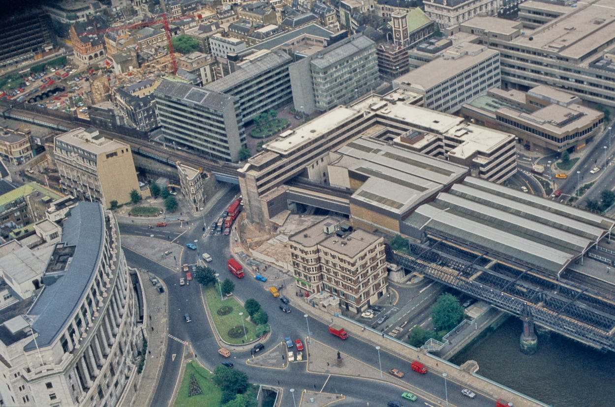

We start in central London with the familiar junction beside Blackfriars station and Blackfriars Bridge. The 1984 photo looks almost artificial — a Toy-Town tilt-shift — perhaps because the choice of camera film accentuates the primary colours against the beige, concrete topology. The 2025 photo also looks artificial, but that’s because it is — a Google Earth construct.
The two views look superficially similar, but significant change has taken place. Blackfriars station has been entirely rebuilt. The 2009 works brought a new entrance, and complete coverage of the cross-river platforms with solar panels (among other changes too numerous to detail here). Note also the two different leviathan groundscrapers that occupy the site at the centre-top of each image. This is now 160 Queen Victoria Street, London home to BNY Mellon. I’m not sure who was in the concrete monster in the 1984 photo. In yet another earlier incarnation, this site was home to The Times newspaper.
Incredibly, the hulking Baynard House complex, which grips Blackfriars station in a chokehold, is still with us, despite looking more dated than a Walls Vienetta at a roller-disco.
Tower Hill looking towards the East End
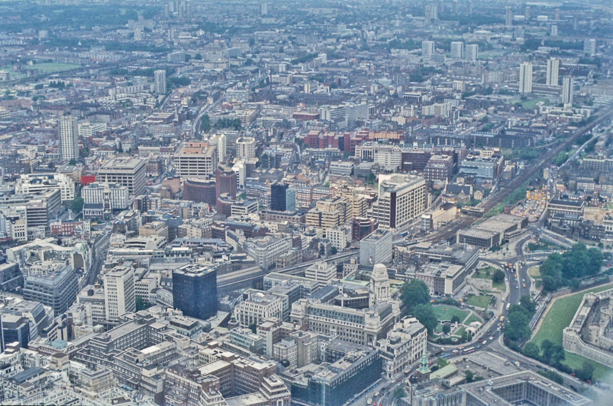

That’s… a lot of buildings. If you’re struggling to get your bearings, we’re hovering close to the Tower of London, which pokes its medieval nose into the bottom-right. You might also spot the former PLA building jutting up at the lower-centre (and more evident in the 1984 shot). Not a lot to say here, really. Many of the buildings have been replaced to meet modern office standards. Otherwise, it’s a confusing sprawl in either era. One notable arrival in the second image is the rebuilt Royal London Hospital, the blue building top-centre.
Bow and Tower Hamlets Cemetery
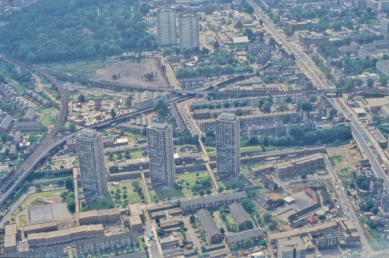
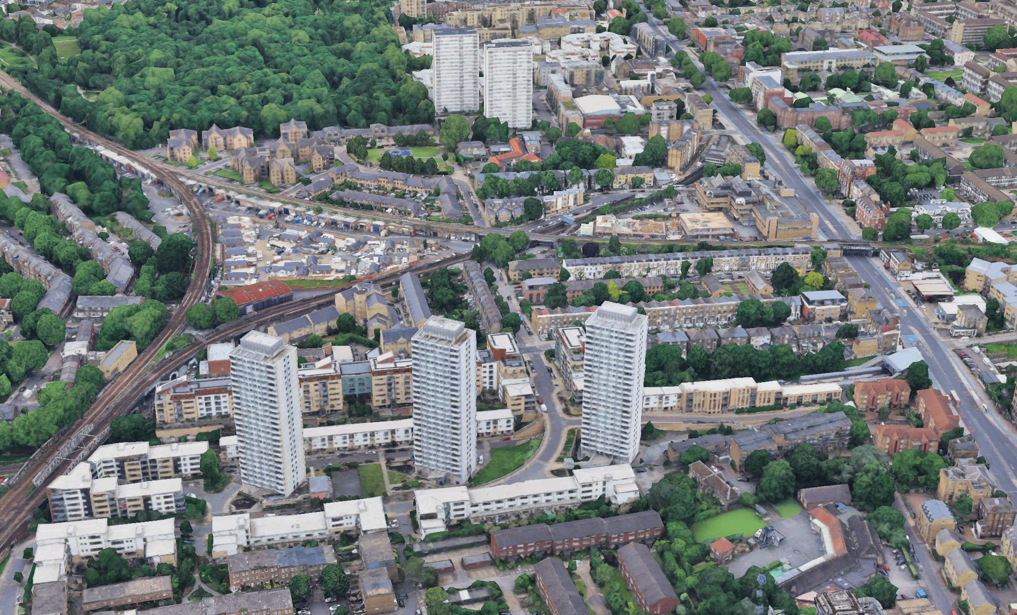
Here, we’re looking roughly westward from Bromley-by-Bow. The two shots show little change over the intervening 40 years. The most salient feature is the three towers of the Crossways Estate, which have been reclad in icy white, along with their long-and-low neighbours. Towards the top we see the ‘Bow triangle’ or rail lines, and beyond the greenery of Tower Hamlets Cemetery Park. Bow Road (the A11) runs to the right.
Stratford station
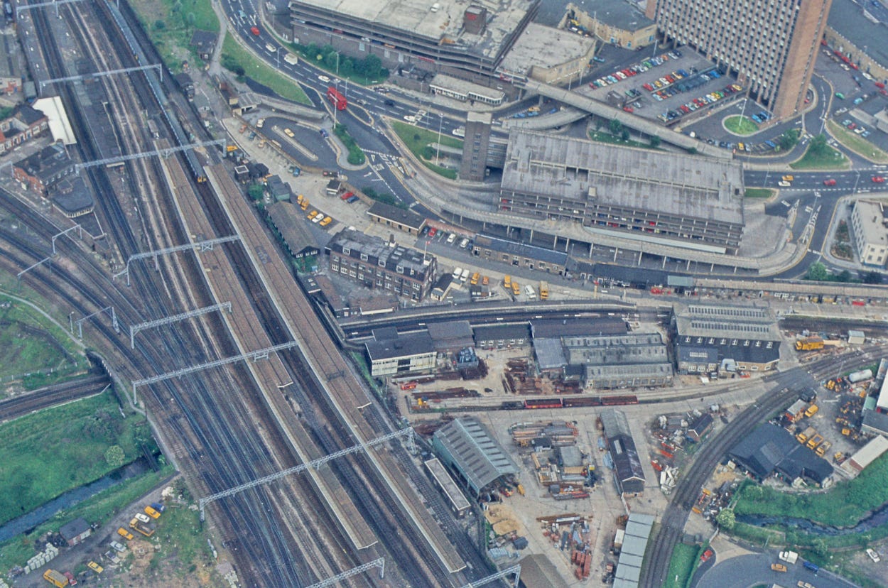

We now come to a sequence of shots around the Stratford area. (For the benefit of overseas readers… this is not the Stratford of Shakespeare fame, but a prominent east London neighbourhood.)
Stratford has changed utterly in recent years. I remember, back in 2006, climbing that multistorey car-park at the top of the first image to cast a beady eye to the west, where the Olympic Park and Westfield shopping centre would soon rise. Both of those are off the edge of our images, which instead show central Stratford, including the railway and bus station. The basics are still the same here, though it’s clear that plenty of heavy engineering has taken place. Since the 1984 photo was taken, Stratford has welcomed the Jubilee line, Elizabeth line and DLR services, as well as beefed-up Overground trains. We also see a rash of new towers, which would be even more apparent if the camera panned or zoomed out.
For all the construction that’s taken place at Stratford, it still feels like a work in progress. I strongly suspect that, were some future me to run through this exercise again in 40 years time, the Stratford landscape would be very different again.
Central Stratford
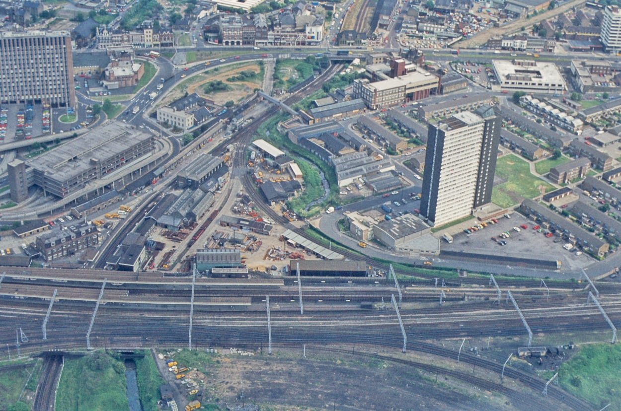

This view is orthogonal to the last one. To align your compass, the brown tower block to the top left is the same one shown in the top-right of the previous images. We’re looking south-east. These images show just what a complicated place Stratford is. Such a tangle of roads, rails and rivulets, slap up against the residential Carpenters Estate (right). The details have changed between eras, but the nature of Stratford, as a busy interchange, has not.
Stratford rail lines
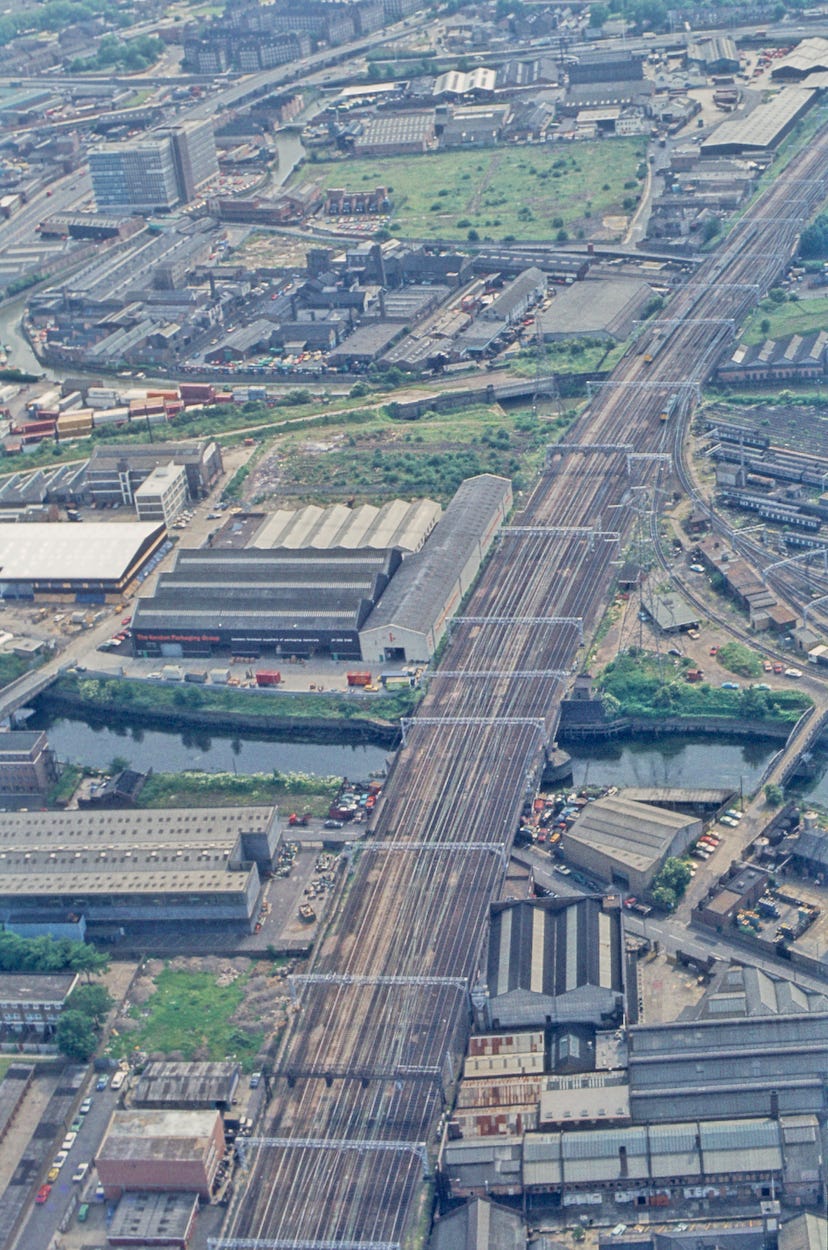

And now we’ve turned the full 180 degrees, to look back along the tracks towards central London. I’ve purposely zoomed out a little to show a wider area in the Google Earth re-creation, so that part of the Olympic Park comes into view. The building lower-right, which looks like an overweight stapler is UCL East, a spectacular new university building that only recently opened. Part of the maroon Orbit tower can be seen extreme right. This land, as is very clear in the first image, was previously industrial as far as the eye could see. Now it’s an inchoate mix of residential, educational, commercial and sites still awaiting development.