


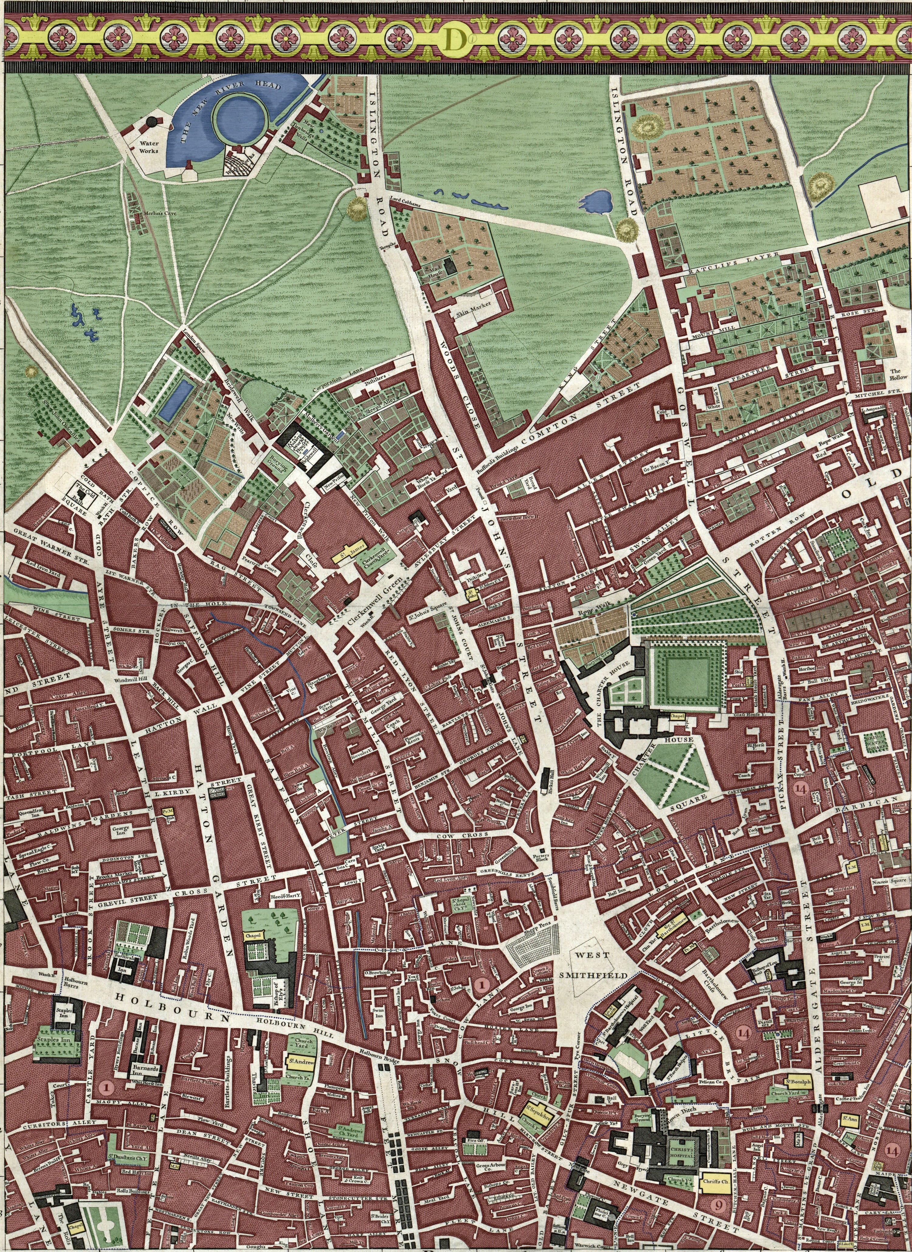
The Lost Places of Clerkenwell
London Spaw, Merlin's Cave and Ratclif's Layer.

Welcome to Friday’s edition of Londonist: Time Machine for paying subscribers, with a generous teaser for everyone else.

Today, I’m gazing further into the seventh panel of the John Rocque map, which I coloured-in and published in the last newsletter. This panel contains numerous intriguing names. What is London Spaw? What went on in Merlin’s Cave? Who might visit The Cold Bath? And what’s in all these places now? Answers to come, in the main section. First, an announcement and the History Radar.
📣📣 SITE VISIT! I’m delighted to announce the first historic site visit of the year, open to all paying subscribers. On the afternoon of 6 March (3pm), we’ve been invited inside Christopher Wren’s Temple Bar — the gateway that now stands between St Paul’s and Paternoster Square. The building has an utterly fascinating history, which will be explained in a short lecture beforehand. Afterwards, I will of course be keen to visit one of the area’s historic pubs, should anyone wish to join me. To get your name on the list, please email me on matt@londonist.com (paid subscribers only). It’s a small space, so we can only accommodate about 15 people. The site visit is free of charge, though donations to the venue would be most welcome.
History Radar
Upcoming events of interest to London history fans. It’s slim pickings this week…
🥁 CHARLES I: A reminder that this Sunday (26 January) will see dozens of Civil War enthusiasts march along Whitehall in full period costume to remember the “Horrid Murder” of King Charles I in 1649. Catch it between 11am and 1pm.
🏰 ROMAN FORT: See the remains of Roman London in the City on 27 January, on a guided walk led by London Museum Docklands. Tour the West Gate of the Roman Fort of Londinium, find out what it was originally used for, and how it was rediscovered after the Second World War.
🕯️ SOANE LATE: The Sir John Soane's Museum stays open late for after-dark exploration on 31 January. On-hand experts offer pop-up talks on their favourite artefacts, works of art, and stories from Soane’s life. Your ticket includes a glass of Prosecco or white wine in the Library Dining Room.
💣 WOOLWICH WORKS TOUR: Take a free guided tour of Woolwich Works on 2 February. You’ll see a group of Grade II and II* listed heritage buildings dating back over 300 years, formerly part of the Royal Arsenal Woolwich, now a cultural centre. Hear stories on topics including London’s first fireworks displays, king and queens, and suffragette protests.
The Lost Place Names of Clerkenwell
The ancient village of Clerkenwell was still a frontier town in the mid-18th century. London was expanding fast, but it had yet to overpower the fields north of Clerkenwell Green. This was still a place of country tracks, open fields and market gardens.
Edgelands are always interesting. They attract the kinds of buildings and businesses that might cause problems in the central city, but which still need to be near population centres. So here, in yonder meadows and pastures, we find a ‘skin market’, a ‘mad house’, a water works, isolated taverns that what we’d now call country pubs, and a thriving balneocopia of spas. Today, I’ll be picking out some of the more interesting features from the map, and explaining their origins.
For convenience, I’ve once again embedded the newly colourised section of the John Rocque map below. I suggest you open it in a separate tab or on a second device, while reading the following descriptions.
In alphabetical order…
Brick Lane: Off Old Street, extreme-right. London had a hod-full of Brick Lanes at this time. The city’s rapid expansion needed lots of bricks, and happily London was blessed with plenty of clay. It was excavated from the city fringes and turned into stock. Brick Lane north of Old Street communicated with the brick fields. Its name was changed to the yawnsome Central Street in the 1860s to avoid confusion with other Brick Lanes. Today, there is only one of note, in Spitalfields, and it is world famous.
Clerkenwell Green: Centre left. This still exists, of course. Its chief curiosity is that there is no green on Clerkenwell Green. Nothing on the Rocque map suggests it was grassy in the 18th century either. The space recently underwent a major re-landscaping… and still it’s all paved with no lawn. It is London’s least-green Green.
The Cold Bath: Centre left. This part of London was once awash with natural springs. The Cold Bath Spring was discovered hereabouts in 1697 and soon gained a reputation for its medicinal properties. A spa grew up on the site, housed inside the building labelled on the map. Cold Bath Square, which half exists today, also sprung from the spring.
The name came to have more negative connotations in the next century, when the hulking Cold Bath Fields Prison was built in the field to the north. Mainly used for debtors and those serving short sentences, it nevertheless had a bleak reputation. Today, the site is the Mount Pleasant sorting office. If you’ve ever scooted around on the Mail Rail attraction, then you’ve been through its basement.
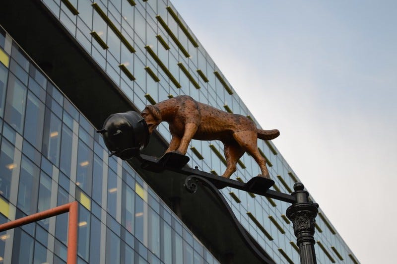
Dog’s Head and Pottage Pot Alley: Off Old Street extreme mid-right. A name so evocative, it could be a side-turning out of Harry Potter’s Diagon Alley. In reality, whenever you see a name like this, it usually recalls a local tavern or shop sign. The image of a dog with its head in a pot was described a hundred years after our map by Charles Dickens, only he was walking along Blackfriars Road a mile from this spot. Dickens’s “golden dog licking a golden pot” was recreated a few years ago, and stands to this day near Blackfriars Bridge. Given two separate instances of the motif, we can speculate that the sign might have been reasonably common. Or perhaps the business moved at some point.
Hicks’s Hall: Lower centre. Something of a vehicular obstruction, Hicks’s Hall (sometimes Hicks Hall) was the main sessions house (courthouse) for the area from 1612 to 1782. The name comes from Sir Baptist Hicks, a wealthy merchant who paid for its construction. Hicks’s Hall had a secondary purpose, which conferred wider fame. The hall marked the start of the Great North Road and, as such, was the location from which all distances from London were measured (a role now played by the Charles I statue at Charing Cross). The building was demolished in 1782, but its footprint remains today as an attractive meeting point for street trees.

Islington Road: Top, centre. There are two of them. I’m not sure why. Is this an error, or were both routes genuinely known as the Islington Road? Today, they are St John Street and Goswell Road.
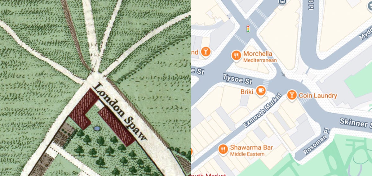
London Spaw: Top-leftish, at the junction of seven tracks. London Spaw could be the name of a horror film, or bash-em-up zombie video game. In fact, it was a well-known tavern specialising in the sale of spa waters from one of the Fleet Valley springs (see New Tunbridge Wells below). Spaw is simply an alternative pronunciation of Spa. The tavern, first recorded in 1685, would give its name to Spa Fields. The site is today the eastern end of Exmouth Market, which has preserved the complicated junction.
Merlin’s Cave: Top-left, below New River Head. Merlin’s Cave! Tell me, honestly, did you expect to find an Arthurian landmark in fields below Islington? But there it is, a magical retreat far from any house or home. There have been attempts to ascribe pagan or occult significance to the landmark. Sealed caves and secret tunnels are rumoured. In London, secret tunnels are always rumoured. Is there any truth in the Merlin myth?